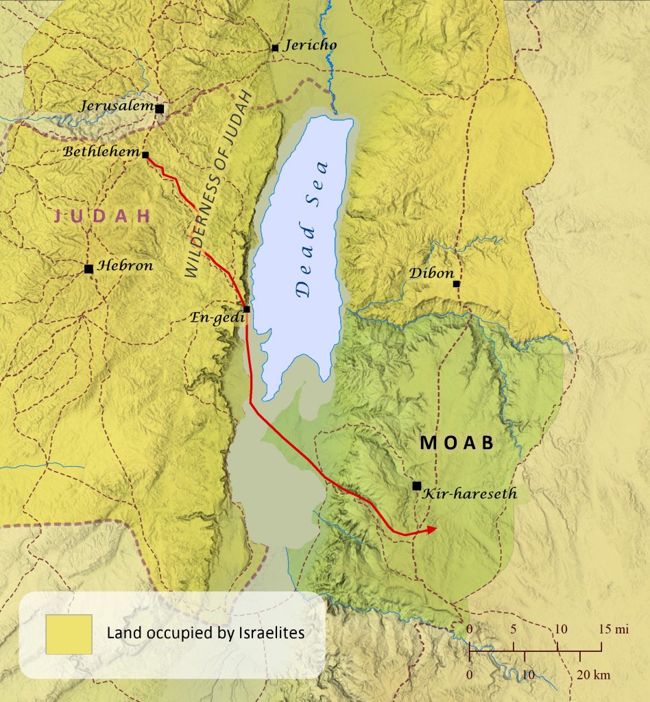
The story of Ruth is set in the time of the Judges, a few generations before the birth of King David. While much animosity often existed between Israel and Moab (Judges 3:12-30; 10:6-12:7; 2 Samuel 8:2; 10; 2 Kings 3:4-27; 2 Chronicles 20; see also Nations across the Jordan River map), other times the two nations appear to have enjoyed a somewhat congenial relationship, as is demonstrated by Naomi’s willingness to relocate to Moab to seek relief from a famine. Later Naomi’s sons also marry Moabite women, and Ruth’s devotion to Naomi and her God no doubt speaks highly of the character of many Moabites. Many years later Ruth’s great-grandson David placed his parents in the care of the king of Moab while he was on the run from King Saul (1 Samuel 22:3-4).
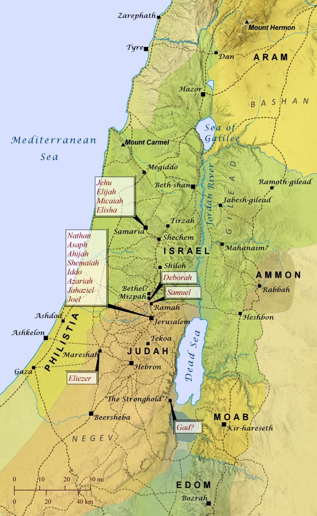
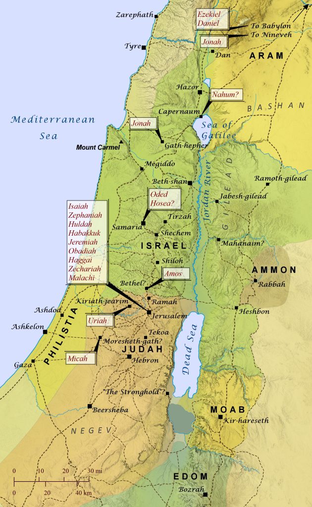
If you ask someone today what biblical prophets did, he or she will likely tell you that they divinely foretold of future events. While this was often the case, most prophets in the Bible focused as much on “forthtelling” God’s messages as they did on “foretelling” the future. That is, their primary role was to simply “forthtell” divinely acquired messages to leaders and groups of people, and at times that included foretelling of coming judgment, blessing, rescue, etc. Also, though plenty of prophets (sometimes called “seers” in Scripture) often spoke in confrontational or eccentric language that put them at odds with kings and religious leaders, the biblical writers also applied the term prophet to people who communicated God’s messages in ways that many readers today might not think of as prophecy, such as worship leaders appointed by David to “prophesy with lyres, harps, and cymbals” (1 Chronicles 25:1). Similarly, the books of Joshua, Judges, 1 & 2 Samuel, and 1 & 2 Kings are typically categorized as history by Christians, but in the Hebrew canon they belong to the category of Former Prophets. The Lord raised up prophets throughout all of biblical history, from the giving of the law under Moses to the revelation of the last days by the apostle John, and the kings of Israel and Judah often recognized and supported specific people as official prophets of the royal court and consulted them to find out God’s perspective about official matters. Following is a list of nearly everyone designated as prophet or seer in the Old Testament and the primary area of their ministry.
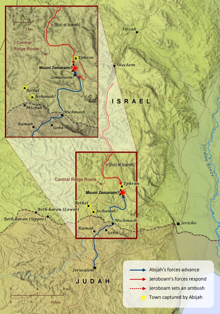
From Sunday School lessons to inspiring sermons, modern portrayals of biblical characters often suffer from overly simplistic, two-dimensional perspectives on people’s moral character and deeds, but a careful reading of Scripture often shows reality to be more complex. The story of Abijah is ripe for similar misunderstanding unless one reads both biblical accounts of his reign. Abijah (also called Abijam) son of Rehoboam reigned for only three short years over Judah, and 1 Kings 15:3 tersely notes that “he committed all the sins that his father did before him; his heart was not true to the Lord his God.” It also notes that Abijah’s entire reign was marked by war with Jeroboam (1 Kings 15:6). From this it would be easy to assume that his reign was characterized only by wickedness and moral decline. Yet 2 Chronicles, though silent on the final assessment of Abijah’s overall character, seems to present Abijah as a leader who takes up the righteous cause of bringing the rebellious northern tribes of Israel back under the fold of Judah’s Davidic dynasty and Aaronic priesthood, though he was ultimately unsuccessful. As part of this effort, Abijah makes a foray into the northern tribes’ territory and arrives at Mount Zemaraim, but Jeroboam confronts him there with twice the amount of forces. The location of Mount Zemaraim is not certain, but it may have been located at the twin hills (which may explain the dual form of the name) of Ras ez Zemara, which suggests Abijah was advancing along a secondary route to avoid initial detection or fortifications along the main Central Ridge Route. There Abijah calls upon Jeroboam and all Israel to return to the leadership of David and Aaron. While Abijah is making his appeal, however, Jeroboam positions some of his forces in ambush behind Abijah’s forces, but Abijah’s men win a great victory over them and capture the towns of Bethel, Jeshanah, and Ephron (also called Ophrah). The writer of Chronicles notes that Abijah’s forces were victorious “because they relied on the Lord” and that Jeroboam never recovered from his weakened power for the rest of his reign, while Abijah grew strong (though Abijah’s reign was only for three years).
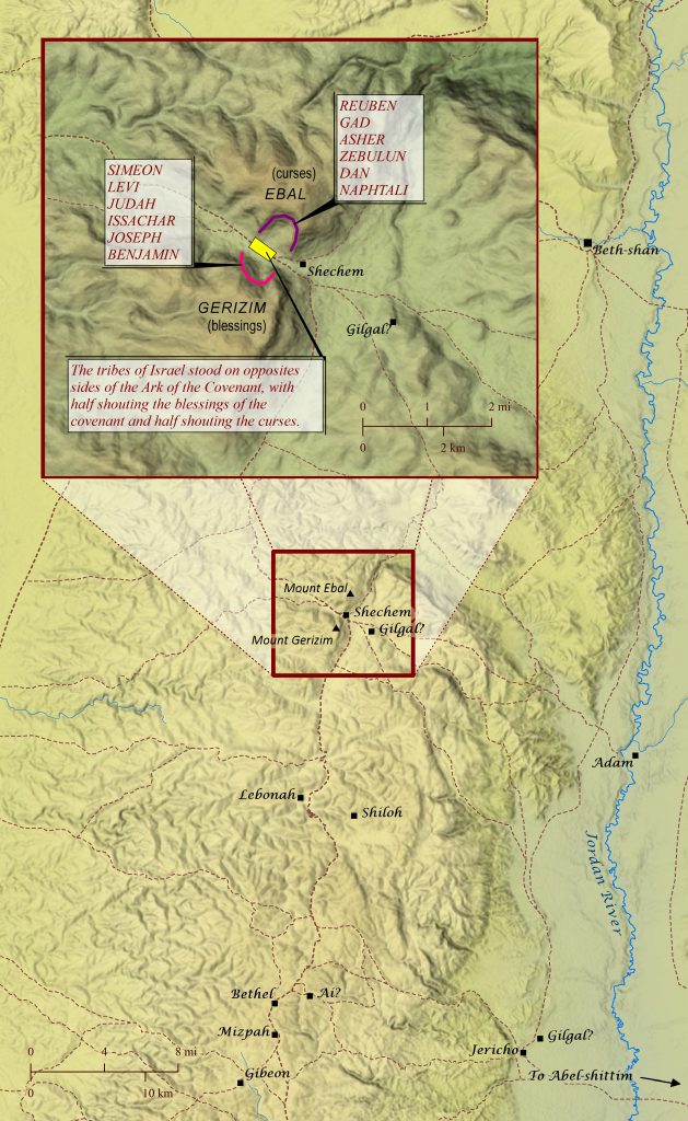
A quick search on the internet reveals that some of the top ways to commit something to long term memory include: 1) organizing the information; 2) making associations; 3) using visual cues (graphs, etc.); 4) creating mnemonic devices (rhymes, acrostics, etc.); 5) writing it down; 6) saying it out loud; 7) quizzing yourself; 8) and rehearsing it (https://www.usa.edu/blog/science-backed-memory-tips/). There should be no doubt, then, that the covenant renewal ceremony at Shechem would have been a truly memorable event for all involved. Two times in the book of Deuteronomy the Israelites are instructed to renew the covenant at Mount Gerizim and Mount Ebal after they have entered the Promised Land of Canaan, and then the actual event is recorded in the book of Joshua. Located in the heartland of Israel, Mount Gerizim and Mount Ebal sat on either side of the ancient city of Shechem, where the Lord had promised centuries earlier to give Canaan to Abraham and his descendants (Genesis 12:6-7). The renewal ceremony was essentially the corporate, verbal affirmation of the terms of the covenant that the Lord had established with Israel at Mount Sinai. As with virtually all ancient Near Eastern covenants, the terms included blessings for those who remained faithful to it and curses for those who broke it. Joshua and the priests stood between the two mountains with the Ark of the Covenant and read the entire book of the law. Six of the tribes (Simeon, Levi, Judah, Issachar, Joseph, and Benjamin) stood in front of the Ark on Mount Gerizim and shouted to accept the blessings for faithfulness to the covenant, and six of the tribes (Reuben, Gad, Asher, Zebulun, Dan, and Naphtali) stood in front of the Ark on Mount Ebal and shouted to accept the curses for unfaithfulness. It is very possible that this ceremony was performed within a natural amphitheater that exists even today on both Gerizim and Ebal at the place shown on this map. By standing within the concave spaces of the two mountains, the tribes would have been both “on” the mountains (Deuteronomy 27:11-13) and “on opposite sides of” the Ark (Joshua 8:33), and they would have been entirely capable of hearing Joshua’s words as well as each other’s shouts of acceptance of blessings and curses. As far as why Gerizim was assigned the place of blessing and Ebal the place of curses, it is not entirely clear, but it may be because the ancients typically regarded east as being in front of them, so Gerizim would have been located on their right, which was typically favored over the left. Also, commentators have often expressed confusion over the mention of “the arabah” and “Gilgal” in Deuteronomy 11, typically because it is assumed that they refer to the Jordan Valley and the Gilgal near Jericho, respectively. This author, however, is convinced that “the arabah” (often meaning, “plain”) refers to the small plain immediately east of Shechem. And “Gilgal” (meaning, “wheel/circle”) in this verse refers to a location just across the plain at Khirbet Gulegil. (The name “Gilgal” was likely applied to at least four locations throughout Canaan; see Joshua 4:19; 15:7; Judges 3:19; 2 Kings 2:1; 4:38; Deuteronomy 11:30.) Centuries later, a Samaritan temple was built atop Mount Gerizim after foreign peoples were resettled in Israel, and this is what the Samaritan woman was referring to when she said to Jesus, “Our ancestors worshiped on this mountain, but you say that the place where people must worship is in Jerusalem” (John 4:20). But Jesus replied to her, “Believe me, the hour is coming when you will worship the Father neither on this mountain nor in Jerusalem….But the hour is coming, and is now here, when the true worshipers will worship the Father in spirit and truth” (John 4:21-23; see also “Shechem and the Hill Country of Samaria” map).
Though the patriarch Isaac moved from place to place several times within southern Canaan, compared to his father Abraham and his son Jacob, Isaac appears to have been a bit of a homebody. In fact, unless Isaac resettled in places not recorded in Scripture, the farthest extent he ever traveled appears to have been only about 90 miles (113 km). Yet, as the child of God’s promise to Abraham to build a great nation from his descendants, Isaac’s relatively simple life served as a critical bridge from Abraham to the beginnings of the twelve tribes of Israel, who were descended from Isaac’s son Jacob. It is likely that Isaac was born at Beersheba (see Genesis 21:1-24), and later Abraham offered him as a sacrifice on Mount Moriah (located at Jerusalem; see 2 Chronicles 3:1). Then Abraham, Isaac, and those with them returned to Beersheba (Genesis 22:1-19). When Isaac reached adulthood, his father sent a servant to bring back a bride for him from Aram-naharaim, far north of Canaan. When his bride, Rebekah, arrived, Isaac had just come from Beer-lahai-roi and settled in the Negev (Genesis 24:62). Later Isaac resettled with Rebekah in Beer-lahai-roi, and this may have been where their twins son Esau and Jacob were born. A famine forced Isaac to go to Gerar (Genesis 26:1-6) in “the land of the Philistines.” The distinct people group known as the Philistines in later books of the Bible did not arrive until the time of the Judges, so the term here must have referred to another people group living in this region, and this is supported by the fact that King Abimelech’s name is Semitic, not Aegean (the likely origin of the later Philistines). While Isaac was there, he repeated his father’s error (Genesis 20) by lying to the king that his wife was only his sister. Isaac also became increasingly prosperous at Gerar, so the Philistines told him to leave their region. Isaac moved away from the town of Gerar and settled further away in the valley of Gerar. There he dug a well, but the Philistines claimed it for themselves, so he called it Esek, meaning “argument.” So Isaac’s men dug another well and called it Sitnah (meaning “hostility”), but it led to more quarreling, so he dug yet another well and called it Rehoboth (meaning “open space”). The locations of these two later wells are not certain, but they may have been located near Ruheibeh as shown on this map. Then Isaac moved to Beersheba and built an altar. He also dug a well there, and King Abimelech of the Philistines came and exchanged oaths of peace with him. It was likely at Beersheba that Isaac blessed his sons Esau and Jacob, and both sons eventually left Canaan (see “Jacob Goes to Paddan-Aram” map). When Jacob later returned, he traveled to Mamre near Hebron and reunited with Isaac (see “Jacob Travels to Southern Canaan” map). Sometime after this Isaac died, and Jacob and Esau buried him there.

