The division of the kingdom of Israel following Solomon’s death is recounted in 1 Kings 12. Only the tribe of Judah remained loyal to the dynasty of David, while the rest of the tribes pledged their loyalty to Jeroboam, one of Solomon’s former officers in charge of forced labor.
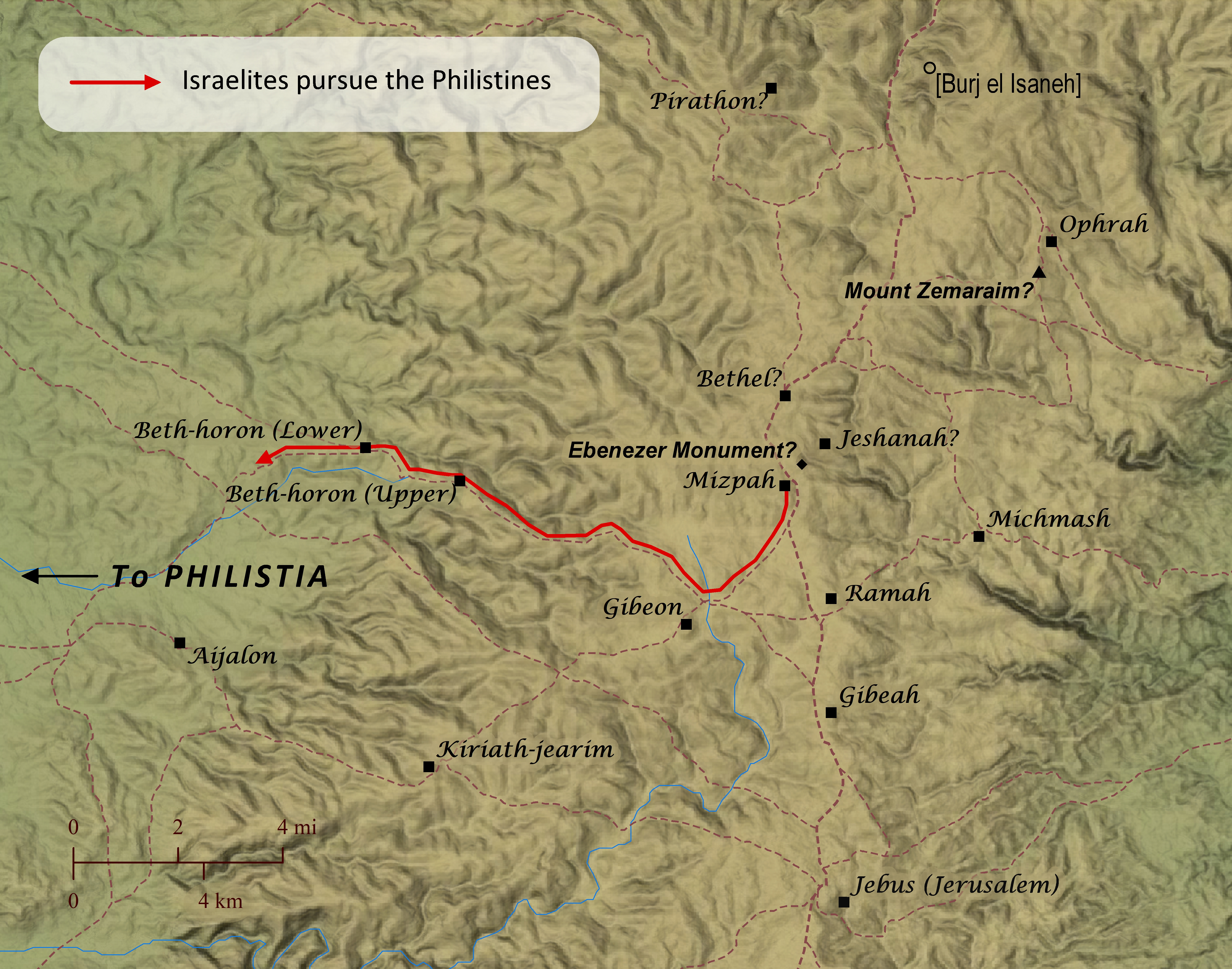
Sometime after the ark of the covenant was returned to Israel from Philistia (1 Samuel 4-6; see “The Ark of the Covenant Is Captured And Returned” map), Samuel called upon the Israelites to put away their foreign idols and worship the Lord alone. He called the people to a dedication ceremony at Mizpah, and he set up his court there to perform his role as judge. When the Philistines heard that the Israelites were gathered at Mizpah, the Philistines prepared to attack them, and the Israelites became afraid. So they asked Samuel to pray for them. After Samuel prayed for them and offered a sacrifice to the Lord, the Lord thundered with a mighty voice and threw the Philistines into confusion. The Israelites chased the Philistines from Mizpah and struck them down as far as Beth-car. Then Samuel set up a stone monument between Mizpah and Jeshanah and named it Ebenezer, meaning, “stone of help.” The name Beth-car is mentioned nowhere else in scripture, but the context of the story and the spelling of the word make it likely that the town intended was actually the same as Beth-horon (technically pronounced more like “Beth-choron”), and the Greek translation of the Old Testament also reads “Bethchor.” Beth-horon was a town–actually twin towns–that stood along a key route leading westward from Gibeah and Gibeon to the land of Philistia. Similarly, the term Jeshanah, near which Samuel erected a stone monument, is mentioned only one other place in scripture (2 Chronicles 13:19; see “Abijah Attacks Jeroboam”), making it difficult to pinpoint the location intended. Virtually all scholars today identify modern Burj el Isaneh as Jeshanah, primarily based on the similarity of the spelling between the modern and ancient names. But this author regards this identification as very unlikely, because Burj el Isaneh seems too far removed to fit the setting of either story very well. In the case of Samuel’s monument, it seems unlikely that the author would use two locations so far apart to indicate where Samuel set up his monument, especially since the span between these two points also passed by Bethel–one of the most noteworthy and enduring locations in the Old Testament. Why wouldn’t the biblical writer have used Bethel instead to indicate to the reader where the monument was located? Rather than locating Jeshanah at Burj el Isaneh, however, this author has found that Khirbet Nisieh would be a much more fitting site for the location of Jeshanah. Khirbet Nisieh’s proximity to Mizpah fits the setting of the story well and makes it a much more helpful indicator to readers regarding where Samuel’s monument was erected. Likewise, the name Jeshanah is likely derived from the word for “crag,” which would be an apt description of the surroundings of Khirbet Nisieh. Finally, the spelling of the modern Arabic place name is similar to that of Jeshanah. Though the sounds that make up the two words are somewhat out of order from each other, such reordering was a common occurrence as place names were handed down from generation to generation throughout the centuries.
Second Samuel 2 details the establishment of David as king over the tribe of Judah and Ish-bosheth as king over the other Israelite tribes. Immediately after this their forces engage in a battle at the border town of Gibeon.
