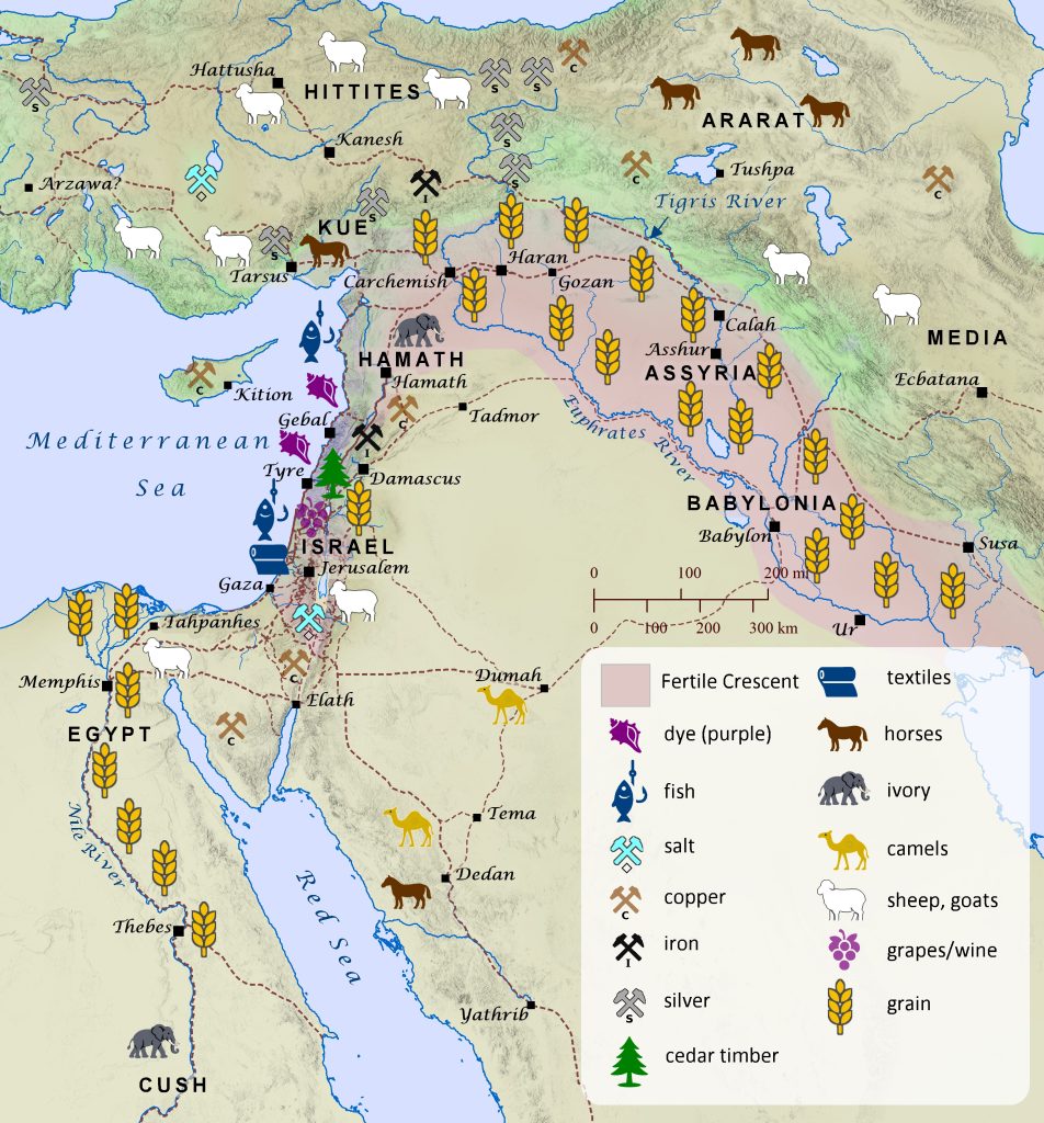
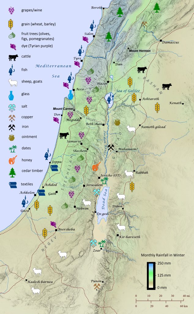
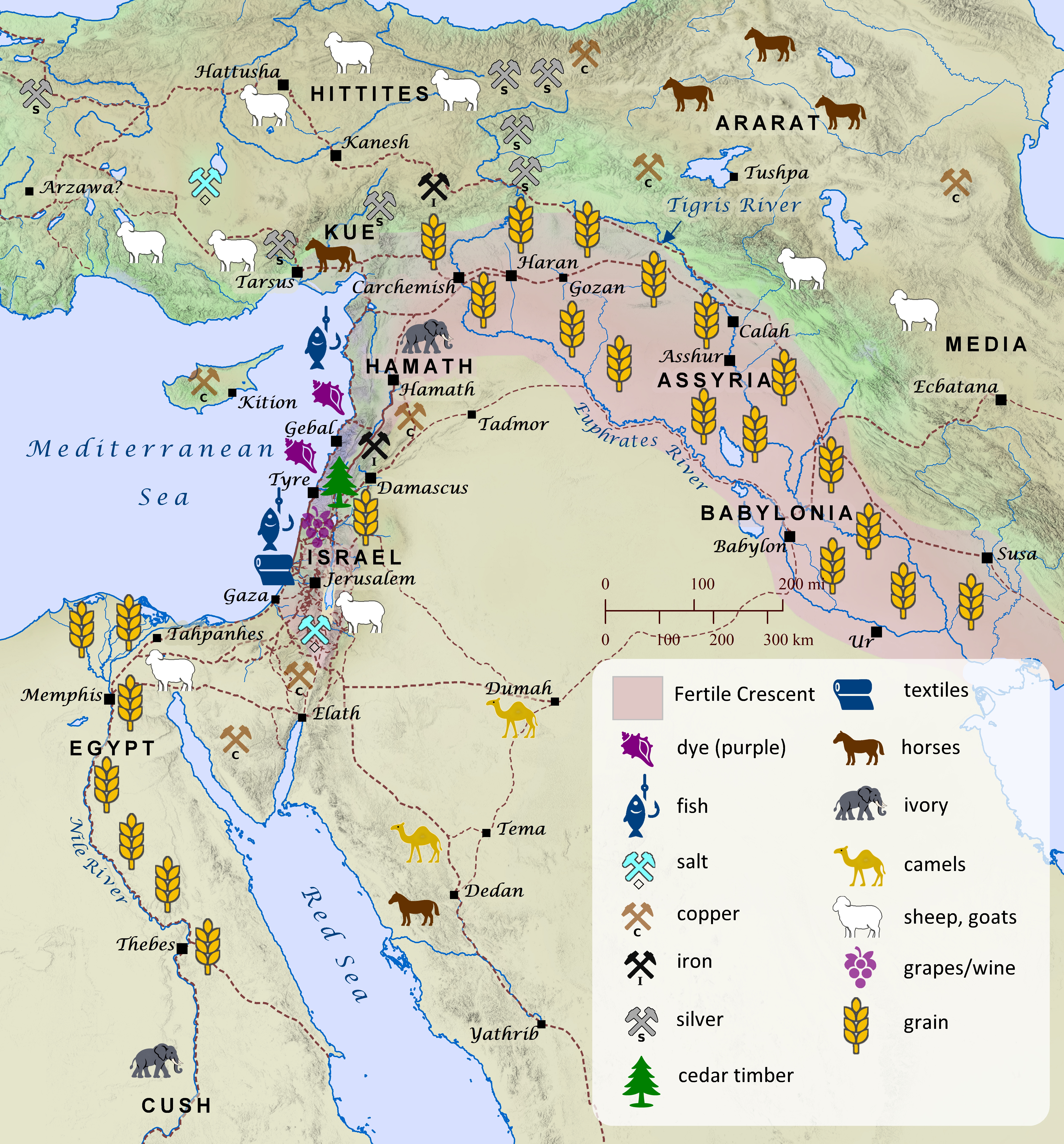
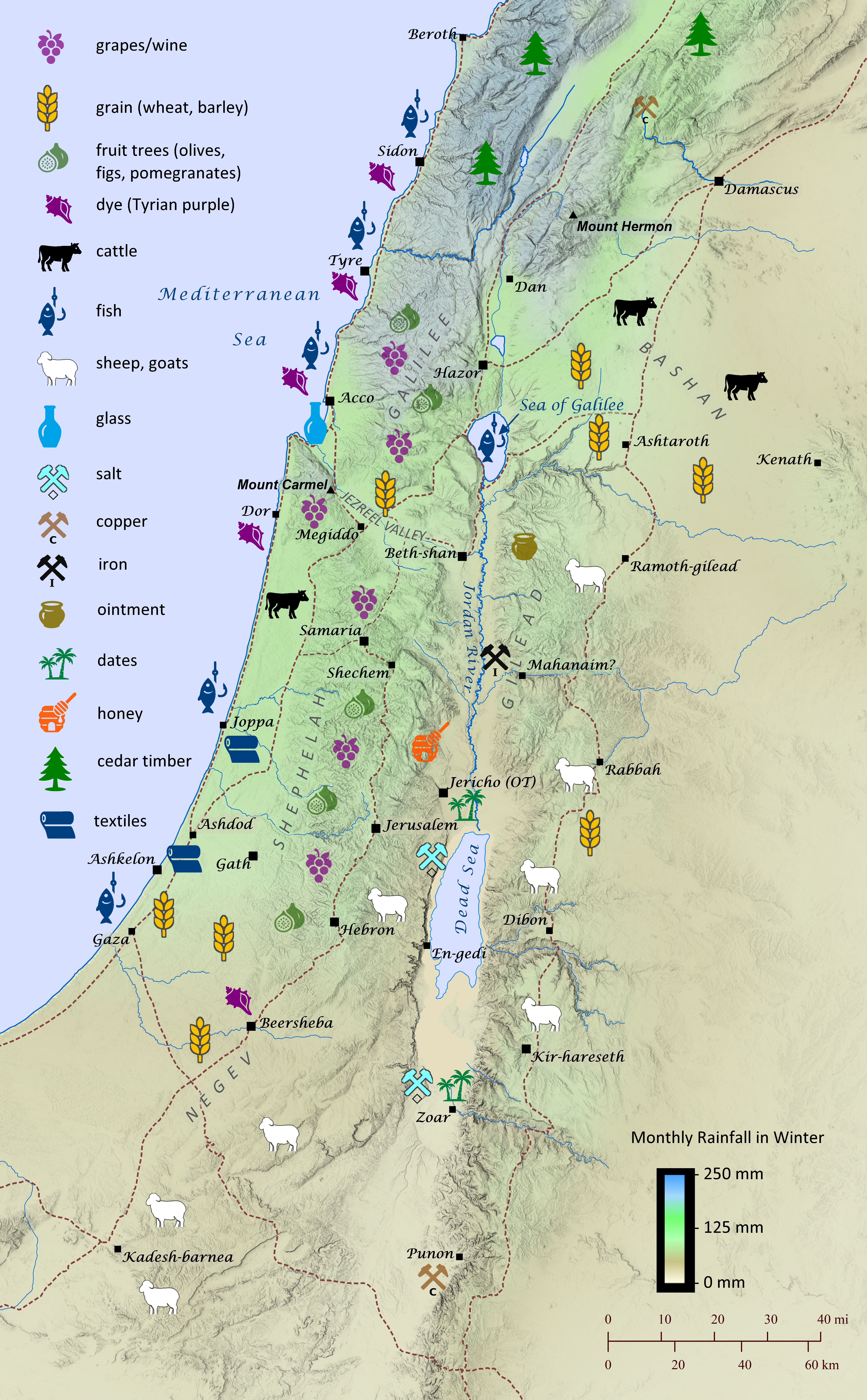
The economy of the ancient Near East, including the land of Israel, ranged from wheat farming and sheep herding to textile production and mineral mining. The land of Israel, though relatively small compared to the great civilizations of Egypt, the Hittites, and Mesopotamia, was particularly diverse in its many industries. This stemmed partially from its rapidly changing elevation and rainfall. Though many of the resources produced were for local consumption, it is clear from archaeology and the earliest stories of Scripture that international trade also played an important role throughout biblical history. The book of Genesis recounts that the patriarch Joseph was sold to Ishmaelite traders traveling from Gilead to Egypt with a load of balm and aromatic resin (Genesis 37:18-36; see “Joseph Is Sold into Slavery” map). Later Joseph rose to power in Egypt, and his own brothers repeatedly traveled from Canaan to Egypt to buy grain during a great famine (Genesis 41-42). During the reign of Saul, the Philistines made strategic use of their exclusive knowledge of iron blacksmithing by restricting any blacksmiths to ply their trade among the Israelites, because they feared they might produce weapons for them (1 Samuel 13:19–22). King Solomon appointed administrative governors to oversee the monthly collection of provisions for the royal court (1 Kings; see “Solomon’s Administrative Districts” map), and he made extensive international trade agreements, buying cedar and cypress timber from the king of Tyre to build the temple and paying him in wheat and olive oil (1 Kings 5:1-12; 2 Chronicles 2). Solomon also engaged in international arms dealing by importing horses from Kue (likely Cilicia) and chariots from Egypt and selling them to the kings of the Hittites and Arameans (1 Kings 10:28–29). His merchant ships traveled as far as Tarshish (likely modern Sardinia or Spain) and Ophir (likely near the southern end of the Red Sea) and returned every three years with precious and exotic goods (1 Kings 10; 2 Chronicles 8-9). His wisdom and riches gained him such international fame that the queen of Sheba in modern day Yemen traveled a thousand miles (1600 km) to visit him (1 Kings 10:1–13; see “Solomon’s International Presence” map). No doubt her intent was also to ensure that the trade routes from Sheba to the Mediterranean ports in southwestern Israel remained unobstructed so that the sale of aromatic resin and precious stones could continue. The Phoenicians of Sidon and Tyre likewise traded extensively throughout the entire Mediterranean world, establishing colonies in places as far away as Tunisia and Spain. During the time of the Judahite exile to Babylon, however, Ezekiel prophesied that the great wealth that the city of Tyre had gained from its worldwide economic trade would one day be swept away (Ezekiel 27; see “Tyre’s International Trade” map). By the time the Romans ruled the land of Israel, the historian Josephus and others note that the olive oil of Galilee had become famous throughout the world for its quality (The Jewish War, Book 2, Chapter 21). Likewise, glass made from the sands just south of Ptolemais (ancient Acco) is mentioned by both Tacitus (The Histories, 5.7) and Pliny the Elder (Natural History, 5.19; see “Poster Map of the Tribe of Zebulun and Its Surroundings, circa 1200 B.C.” map). By this time the Romans had even established trade connections with the land of China by means of the Silk Road (see “Lands beyond Persia” map).


Audio-Visual Reading of 1 Chronicles 5
1 Chronicles 5
The land immediately east of the Jordan River and the northern basin of the Dead Sea, often referred to today as the Transjordan, was conquered by the Israelites as they were preparing to enter the Promised Land (Numbers 21:21-35; 32:1-42; Deuteronomy 2:24-37; Judges 11:19-22). Later, during the time of Saul, these tribes also captured territory from three Hagrite tribes further east in the wilderness. It is possible that the Hagrite tribe of Nodab mentioned in 1 Chronicles 5:19 is the same as the tribe of Kedemah mentioned in Genesis 21:1-21; 25:1-18 (see “Nomadic Range of Ishmael’s Descendants” map). See “Poster Map of the Tribes of Reuben, Gad, and Manasseh (East)” for a detailed map of the territory of these eastern Israelite tribes.
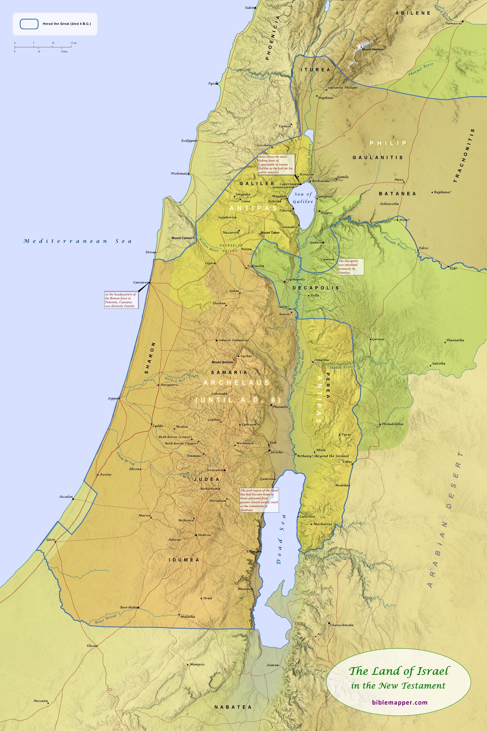
Poster Map of the Land of Israel during the New Testament
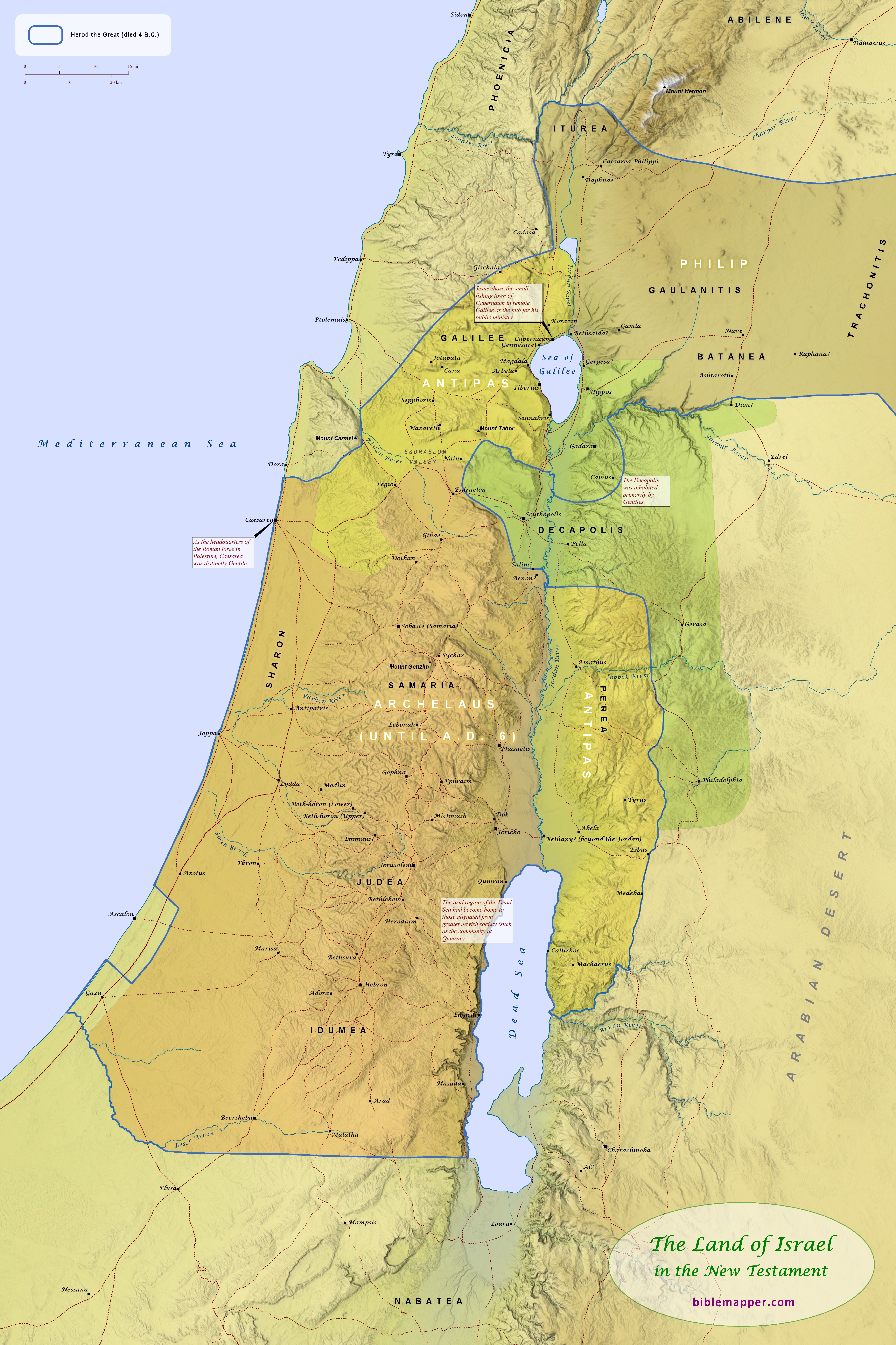
At the time of Jesus’ birth, the land of Israel (now called Palestine by the Romans) was ruled by the Romans, who had granted Herod the Great the title of “king” over the region (see “Palestine under Roman Rule” map). His domain included most of the land that once belonged to Israel. After his death, the Romans granted Herod’s wishes that his kingdom be divided among his sons Archelaus, Antipas, and Philip. The region of the Decapolis (“Ten Cities”) was never included in Herod’s kingdom and had a distinctly Gentile population and character. The cities of this region enjoyed semi-autonomous status under the Romans.

This map is designed to be printed at 24 in. x 36 in., but it may scale acceptably at larger or smaller sizes as well.
Order as a pre-printed, matte poster (2 ft x 3 ft). Price: $24.90, plus shipping and tax.
Audio-Visual Reading of Deuteronomy 2
Deuteronomy 2
Deuteronomy 2 details Moses’ recollection of the Israelites’ journey from Kadesh-barnea to Abel-shittim, where they were now waiting to enter the Promised Land of Canaan. See below for additional information about why certain decisions have been made regarding the identification of ancient locations or stretches of the journey to Abel-shittim.
Four separate passages of Scripture recount the Israelites’ journey from Kadesh-barnea to Abel-shittim (Numbers 20:14-21:20; 33:37-49; Deuteronomy 2:1-23; Judges 11:14-27), but the difficulty of determining the exact route can be seen by the wide variety of routes that have been proposed by scholars over the past several decades. In general, the proposed route in this work most closely aligns with information provided by Numbers 20:14-21:20; 33:37-49; and Deuteronomy 2:1-23, but its differences with Judges 11:14-27 are by no means irreconcilable. In addition, Jephthah’s account in Judges 11 appears to be most concerned with making the case that the Israelites did not encroach on Ammonite land as they journeyed to Canaan, so his description appears to give more of a loose summarization of the Exodus route and the journey to Abel-shittim. Thus, Jephthah does not burden his account with specific details such as the apparent change of plans to travel through Edom instead of going around it (compare Numbers 33:42-43 and Deuteronomy 2:2-6 with Judges 11:18).
Following are additional comments regarding why certain decisions have been made regarding the journey to Abel-shittim and the identification of various ancient locations.
After being refused permission from the king of Edom to take (apparently) a more direct route through his territory, the Israelites “turned back” while they were at Kadesh-barnea on the edge of Edom’s territory (Numbers 20:14-21), thus leading them to head toward the Red Sea (Deuteronomy 2:1).
Regarding the location of Seir, see “Edom and the Land of Seir”.
Regarding the location of Mount Hor, see “The Israelites’ Journeys in the Wilderness”. This article also addresses one of the more challenging elements to reconcile with other passages’ accounts of the route: the location of the king of Arad’s attack on the Israelites.
As noted earlier, after the Israelites passed by Mount Seir, it appears that the Lord directed the Israelites to change their plans to circumvent Edom and instead directed them to pass through it (compare Numbers 33:42-43 and Deuteronomy 2:2-6 with Judges 11:18). See “The Israelites’ Journeys in the Wilderness”.
Regarding turning north at Zalmonah, this fits well with Scripture’s account that, after passing by the Edomites in Seir, the Israelites “turned away from the Arabah road that comes up from Elath and Ezion-geber” (Deuteronomy 2:8), and it also fits very well with Numbers 33:42, which records Punon as the next stop after Zalmonah.
Regarding the verses that require a route that avoids Moab (Deuteronomy 2:9; Judges 11:18) while at the same time making sense of the assertion that the Israelites camped “at Iye-abarim in the territory of Moab” (Numbers 33:44), the location of Khirbat `Aiy in the southwest corner of Moab fulfills these requirements well (“The Journey to Abel-shittim”). This location is also appropriately situated among the Abarim Mountains (as the predicate “-abarim” seems to indicate), which ran along the eastern shore of the Dead Sea. The Medeba Map clearly identifies a town named Ai (a variant spelling of Iye) at the exact location of Khirbat `Aiy. (The stream depicted just south of Ai on the Medeba Map is likely Wadi en Numeirah [identified as the “waters of Nimrim”], not Wadi al-Hasa.) Though many translations understand Numbers 21:11 (“Iye-abarim, in the wilderness bordering Moab toward the sunrise”) as placing Iye-abarim in the wilderness that is east of Moab, this author is convinced that it is saying instead that Iye-abarim is in the wilderness that faces (Hebrew panim) Moab when looking eastward. Other examples of the use of the word faces to place something in a non-eastern position relative to another object by indicating the point of view of the reader include Joshua 13:24-25 (Gad’s boundary could not have included a town that was east of Rabbah) and Joshua 18:14 (it seems to make the most sense that the hill in view is probably the prominent hill to the north of Beth-horon–that is, before it when looking southward).
Regarding the location of the Zered Brook, Numbers 21:11-12 makes it difficult to identify it with Wadi al-Hasa, as the nearly universal scholarly consensus does. The Israelites had just camped at Iye-abarim, north of Wadi al-Hasa, and now they are said to have camped in the Zered Brook as they made their way north. Even if one locates Iye-abarim at El Medeiyineh, that location is itself located in the middle of Wadi al-Hasa, so why would the text then say they camped next in the Zered Brook? Instead, it makes better sense to place the Zered Brook at Wadi e-Tarfawiya (see article at https://www.thetorah.com/article/wadi-zered). (Wadi al-Hasa instead makes a better candidate for the Brook of the Willows, mentioned in Isaiah 15:7.)
Regarding the location of Ar, see article at https://www.thetorah.com/article/ar-moab. Additionally, this author suggests Qasr el-‘Al as a good candidate for the site of the fortress of Ar, which likely gave its name to the greater region that lay south of the fortress. Based on Scripture’s multi-faceted portrayal of Ar, this fortress and region appear to have been considered at the same time Moabite yet to some degree distinct from the Moabites.
Zechariah Prophesies of Judah’s Restoration
Zechariah 14
In the last chapter of his book, the prophet Zechariah describes an apocalypic vision of Judah’s coming restoration. It is not clear whether Zechariah’s vision refers to actual, specific events to come in the future, or whether it expresses a more general hope that one day God will ultimately intervene in history to judge the nations, protect his people, and establish his rule over the world. The vision begins by describing a time of great suffering when all the nations will be gathered for battle against Jerusalem. The city will fall, and half the city will go into exile. Since Zechariah lived after the fall of Jerusalem and the exile of many Judeans to Babylon, this portion of the vision may actually refer to these past events. The vision continues on, describing how the Lord will rise up for those that remain, and he will fight the nations, and the very land itself will be transformed for the Lord’s people. The Lord will stand on the Mount of Olives, just east of Jerusalem, and the mountain will be split in half from east to west, allowing the people of Jerusalem to flee through the new valley to Azal, an uncertain location somewhere east of the city. Living waters will flow out of Jerusalem as well, with half the waters flowing to the Dead Sea (literally, “eastern sea”) and the other half flowing to the Mediterranean Sea (literally, “western sea”). The Lord will become king over all the earth, and the land will become a plain from Geba to Rimmon, essentially the entire land of Judah. It is interesting to note that this restored Judah will once again include the region that was under the rule of the Idumeans (Edomites) at the time of Zechariah. The Edomites had apparently moved northward from Seir into this region while Judah was under attack from Nebuchadnezzar just before the fall of Jerusalem (see Ezekiah 25:12-14; Obadiah 1:1-21; see “Nebuchadnezzar’s Final Campaign against Judah” map). Jerusalem, however, will continue to remain elevated over the surrounding area. The city, which lay in ruins at the time of Zechariah, is described as spanning east to west from the Gate of Benjamin (on the eastern edge of the Temple Mount) to the Old Gate (on the western edge of the Temple Mount) to the Corner Gate (on the far western edge of the city). The city also spanned north to south from the Tower of Hananel to the king’s winepresses, likely near the king’s garden at the southern edge of the city.