Joshua 18
Joshua 18 recounts the allotment of the Promised Land to the remaining seven tribes who had not yet been assigned their inheritance, followed by a meticulous record of the boundaries of the tribe of Benjamin.
Joshua 18
Joshua 18 recounts the allotment of the Promised Land to the remaining seven tribes who had not yet been assigned their inheritance, followed by a meticulous record of the boundaries of the tribe of Benjamin.
For those of you who create or host Bible related content on the web, there is now a simple tool freely available from Bible Mapper that will fetch all related Bible Mapper maps and articles for each Bible reference on your page and link them to a map icon next to the Bible reference. When the user clicks on the map icon, the maps are displayed in a scrollable popup window right beside the reference. The only thing you need to do is add a single a single line of code somewhere in your page that links in Bible Mapper’s ReferenceMapper JS library, and ReferenceMapper does the rest:
<script src='https://biblemapper.com/passagebrowser/reference-mapper.js'></script>(If you prefer, you are also welcome to download a copy of the reference-mapper.js library, upload it to your own domain, and link to it there.) You can see a sample page here and a screenshot below of some sample text with ReferenceMapper enabled:

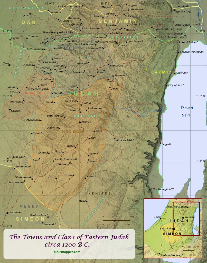
As Israel invaded Canaan and conquered the land, the Israelite tribe of Judah was allotted a very large portion of it for their inheritance. Their territory was the southernmost allotment of all the tribes, stretching from Jerusalem in the north to Kadesh-barnea in the south. In reality, though, their primary area of occupation was limited to the region shown on this map, due to the Philistines’ occupation of the western coast and the extremely arid conditions of the land in the far south. Also, the Bible notes that the allotment of the tribe of Simeon “formed part of the territory of Judah; because the portion of the tribe of Judah was too large for them, the tribe of Simeon obtained an inheritance within their inheritance” (Joshua 19:9), and this is confirmed by the explicit mention of over twenty towns being allotted to both tribes (see Joshua 15:20-63; 19:1-9). The Kenites, who were not ethnic Israelites (they were descendants of Moses’ father-in-law; see Judges 1:16) but lived in peaceful coexistence with them, also occupied the arid land to the southwest of the Dead Sea.
Scripture further details many of the clans and sub-clans of Judah (1 Chronicles 2:1-55; 4:1-23). Most (or perhaps all) of these clan names corresponded with names of various towns in Judah, since towns in ancient Israel were often named after the ancestor of the clan that founded or predominantly occupied the town. Because of this, the boundaries of occupation for the clans of Hur, Shelah, and Hezron can be determined with some certainty and are displayed on this map. Likewise, the clan of Carmi, though lacking any clear references to known towns, may have settled in the general area of the valley of Achor, since the family of their ancestor Achor was famously put to death there (Joshua 7; see “Israel Enters the Promised Land” map). It is also interesting to note that an Israelite judge named Jair was descended from Judah by his father’s lineage, but his father’s mother was from the tribe of Manasseh, and when Jair conquered many towns in Manasseh’s territory of Gilead and Bashan (Numbers 32:40-42; Deuteronomy 3:14; Joshua 13:30; Judges 10:3-5; 1 Kings 4:13; 1 Chronicles 2:22-23; see “Bashan” map), those towns continued to be regarded as belonging to Manasseh. Perhaps this was in keeping with the tribe of Manasseh’s openness to inheritance by female descendants in certain cases, such as with Zelophahad’s daughters (Numbers 27; Joshua 17:1-6; see “Poster Map of the Tribe of Manasseh (West) and Its Surroundings, circa 1200 B.C.”).
Two centuries later the tribe of Judah gave rise to the enduring dynasty of King David, who initially ruled over only the tribe of Judah but eventually over all the Israelite tribes (2 Samuel 2-4; see “David and Ishbosheth” map). After the death of David’s son Solomon, however, the northern tribes revolted, leaving only Judah and Benjamin under the Davidic dynasty’s domain (1 Kings 12; 2 Chronicles 10; see “The Kingdoms of Israel and Judah” map). Several decades after the northern kingdom was exiled by the Assyrians (2 Kings 15:29; 1 Chronicles 5:26; see “Israelites Are Exiled to Assyria” map) the kingdom of Judah suffered a similar fate at the hands of the Babylonians (Daniel 1; 2 Kings 24-25; 2 Chronicles 36; Jeremiah 39; 52; see “Judah Is Exiled to Babylon” map). Unlike the northern kingdom, however, Judah was typically allowed to maintain their common identity and religious distinctives during their time in exile (see The Land of Exile map), thus fostering their sense of continuity with the past tribe and kingdom of Judah.
This map is designed to be printed at 11 in. x 14 in., but it may scale acceptably at larger or smaller sizes as well.
Acts 15
Paul’s first three missionary journeys originated from Antioch, one of the largest cities in the Roman Empire by Paul’s time. Founded by Seleucus I Nicator, it first served as the capital of the Seleucid Empire, and by the time of Paul it boasted a significant Jewish population. Decades earlier King Herod the Great of Judea had funded the building of a marble colonnaded street there that was nearly two miles (3.2 km) long. As persecuted followers of Jesus fled Judea, some of them traveled as far as Antioch. There they led many Jews and even Gentiles to become believers, and it was in Antioch that the followers of Jesus were first called “Christians” (Acts 11:19-26). Antioch was also the starting point for Paul’s first three missionary journeys (Acts 13:1-3; 15:36-41; 18:22-23). After Paul’s first missionary journey, some people came to Antioch from Judea and began to teach that all believers–Jews and Gentiles–must be circumcised and follow the laws of Moses (Acts 15:1). But Paul and Barnabas argued against them. So the church in Antioch sent Paul and Barnabas and other leaders to Jerusalem to discuss this issue with the apostles and elders there. As they passed through Phoenicia and Samaria on their way to Jerusalem, they told others (presumably Jewish believers) about the conversion of many Gentiles to the faith, and all the believers rejoiced with them. After Paul and the other leaders arrived in Jerusalem and were warmly received by the church there, their reports about the conversion of Gentiles led some believers from the sect of the Pharisees to insist that these new believers be circumcised and follow the laws of Moses. After much debate about the matter, the apostles and elders in Jerusalem decided that Gentile believers did not need to follow the laws of Moses except for a few critical requirements: that they abstain from sacrifices made to idols, from blood, from what has been strangled, and from sexual immorality. Then the Jerusalem church sent Paul and the other leaders back to Antioch with a letter stating this decision. After Paul and the others arrived in Antioch and delivered the letter, the church in Antioch rejoiced. Paul and Barnabas remained in Antioch and continued to teach the believers there. Sometime after this Paul and a believer named Silas embarked on a second missionary journey to visit the churches that Paul had helped to found during his first missionary journey, and Barnabas took his relative John Mark to minister in his home region of Cyprus.

⤓ download hi-res file 🔍 see in TimeGlider
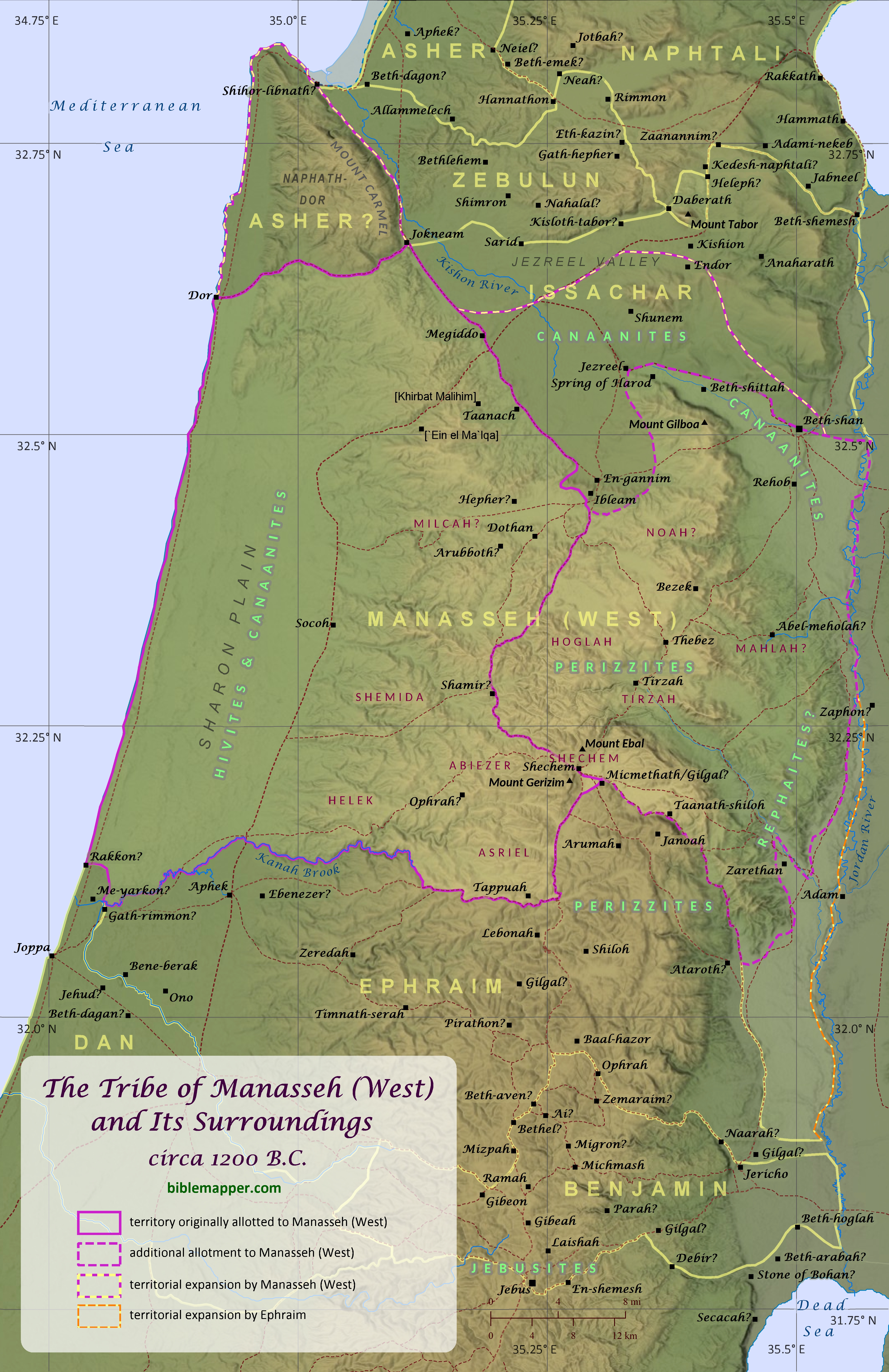
Though Manasseh’s descendants formed only half the tribe of Joseph (the other half being Ephraim) and its population was surpassed by Judah, Issachar, Zebulun, Dan, and Asher (Numbers 26) at the time of their entry in Canaan, Manasseh occupied one of the largest allotments among the tribes of Israel, rivaling even the royal tribe of Judah. Half of Manasseh’s allotted territory was located technically outside the Promised Land of Canaan in the region commonly referred to as the Transjordan (“across the Jordan”), which was seized from King Og as the Israelites approached Canaan from the southeast and prepared to enter the land (Numbers 32:33; Deuteronomy 3:13; Joshua 13; see “Israel Defeats Og and Sihon” map). The other half of its territory (often referred to as West Manasseh) lay in the central region of the Promised Land, and the tribe of Manasseh, sometimes referred to by the name of Machir, Manasseh’s son, was involved in several key events in the early life of Israel. They participated in the victory of Deborah and Barak over Sisera (Judges 5:14; see “Deborah and Barak Defeat Sisera” map) as well as the victory of Gideon (who was from Manasseh) over the Midianites (Judges 7:23; see “Gideon Defeats the Midianites” map). After Gideon died, his son Abimelech briefly made himself king over Shechem and also attacked the town of Thebez in the territory of Manasseh (Judges 9). Manassites were among those who joined David before the battle at Mount Gilboa and also among those who came to make him king at Hebron (1 Chronicles 12; see “The Battle at Mount Gilboa” map and “David and Ish-bosheth” map). Many Manassites were also among those who humbled themselves and accepted Hezekiah’s invitation to attend the Passover in Jerusalem (2 Chronicles 30:11).
West Manasseh’s boundaries eventually stretched from the Mediterranean Sea to the Jordan River, and that is how they are drawn on virtually all maps of the tribe’s territory. But this author is convinced that a careful reading of Joshua 16-17 (particularly Joshua 17:7-12) indicates that, technically speaking, Manasseh’s initial allotment included only the western portion of their full allotment, that is, the land to the west of Tappuah, Shechem, and En-gannim and to the south of Asher (see “Poster Map of the Tribe of Zebulun and Its Surroundings circa 1200 B.B.” map and its discussion regarding southern Asher), as shown on this map (see also 1 Kings 4:10). But the tribe of Joseph (that is, Manasseh and Ephraim) complained to Joshua that their allotted territory in Canaan was not large enough for their growing populations (Joshua 17:14-18). So Joshua responded: “If you are a numerous people, go up to the forest, and clear ground there for yourselves in the land of the Perizzites and the Rephaim” (Joshua 17:15). Then it appears that the tribe of Joseph complained further that even this additional hill country would not be enough, yet they were not confident that they could take land from the Canaanites in the Jezreel Valley (Joshua 17:16). But Joshua assured them, “Since you are so large and strong, you will be given more than one portion. The forests of the hill country will be yours as well. Clear as much of the land as you wish, and take possession of its farthest corners. And you will drive out the Canaanites from the valleys, too, even though they are strong and have iron chariots” (Joshua 17:17-18, NLT). This additional allotment–the forested hill country of the Perizzites and the Rephaim–was likely the mountainous region just north of Shechem and the surrounding towns of Tirzah, Thebez, and Bezek. This is supported by Jacob’s comment in Genesis 34:30 that Simeon and Levi had made him “odious to the inhabitants of the land, the Canaanites and the Perizzites” when they slaughtered the men of Shechem for assaulting their sister. Judges 1:4-5 also references a battle fought against the Canaanites and the Perizzites at Bezek. Prior to the Israelites’ entry into Canaan, Perizzites apparently lived in the hill country near Bethel and Ai as well (Genesis 13:7). The Rephaim, while predominantly associated with the lands across the Jordan River (Genesis 14:5; Deuteronomy 2:11-20; 3:11-13), apparently also lived in Canaan, because the Israelites wiped out many Anakim, who were descendants of the Rephaim, as they were conquering Judah (Deuteronomy 2:11; Joshua 11:21-22; 14:12-15). It should also be noted that Ephraim was included in this promise of an additional lot as well (Joshua 17:17), and the stories of Gideon and Jephthah indicate that by their time Ephraim, not Manasseh, was progressively gaining control over the lower Jordan Valley as far north as Zaphon (Judges 7:23-24; 12:1). Manasseh also began to occupy territory belonging to the surrounding Israelite tribes, including the towns and surrounding villages of Beth-shan, Ibleam, Dor, Endor, Taanach, and Megiddo, though they never fully drove out the Canaanites living there (Joshua 17:11-12; Judges 1:27-28; 1 Chronicles 7:29). As a result, the territory occupied by Manasseh and Ephraim by the completion of the book of Joshua and Judges is notably larger than the land originally allotted to them.
Joshua also records that Manasseh’s tribal allotment was further divided among ten clans of Manasseh, including the families of the daughters of Zelophehad (Joshua 17:1-6). During the Israelites’ wandering in the wilderness, Moses granted Zelophehad’s daughters, whose father had no sons, the right to inherit land, though this was not the normal practice in Israel (Numbers 27). The discovery of the Samaria Ostraca in the palace of Ahab in 1910 has enabled scholars to deduce the likely area in which several of these clans settled within Manasseh’s territory, including Noah, Shemida, Abiezer, Asriel, Shechem, Helek, Hoglah, and Tirzah. This author also suspects that the location of the clan of Mahlah may be preserved in the name of the ruins at Khirbat al Milkh (identified as Abel-meholah on this map) and the nearby stream of Wadi el Maleh. Likewise, this author also suspects the location of the clan of Milcah may be preserved in name of the ruins at Khirbat Malihim and the nearby spring of `Ein el Ma`lqa.

This map is designed to be printed at 11 in. x 17 in., but it may scale acceptably at larger or smaller sizes as well.