2 Samuel 2-4
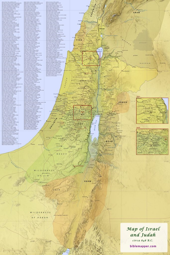
Soon after Saul was killed in battle against the Philistines, David and his family moved to Hebron. There the people of Judah, David’s tribe, anointed him king over Judah. It seems that David then made an indirect offer to Jabesh-gilead to come under his rule as well, but Abner, the son of Saul’s commander, had already set up Saul’s son Ish-bosheth as king over all the other tribes. (The name Ish-bosheth, meaning “man of shame,” may have originally been Esh-baal, as in 1 Chronicles 8:33; 9:39, and was modified by later copyists of Scripture, perhaps to denigrate any association with the name Baal.) A long war ensued between David and Ish-bosheth. During this time, some of Ish-bosheth’s men traveled to Gibeon under the command of Abner, and they faced off at a pool against some of David’s men under the command of Joab, one of David’s nephews (1 Chronicles 2:15-16). Abner suggested that they have a contest between their respective champions, and twelve men were selected from each side to fight. David’s men killed all twelve of Abner’s men, and this led to a fierce battle between all the soldiers. Joab’s brother Asahel was killed in the fighting. Eventually Abner called for Joab to end the fighting between the two armies, and he agreed. Abner’s men then marched all night, making their way through the Jordan Valley (“the Arabah”) and continuing the next morning until they reached Mahanaim. Joab’s men traveled to Bethlehem and buried Asahel in his father’s tomb in Bethlehem, and then they continued to Hebron. Over time David became stronger and stronger, while Ish-bosheth became weaker and weaker.

? download hi-res file 🔍 see in TimeGlider
Land Unconquered by the End of Saul’s Reign
Joshua 13:1-6; Judges 1:21-36
Though Numbers 32 and Joshua 13-20 carefully detail the boundaries of each Israelite tribe’s allotted land (see map), much of this land was still occupied by Canaanites, and the Israelites often struggled to establish dominion over their inheritance. In particular, the lands along the Mediterranean Sea, in the plain of Bashan, and in the Jezreel and Sorek Valleys proved to be very difficult for the Israelites to occupy. In some cases the Israelites were eventually able to drive out the Canaanites, but in other cases they were only ever able to subject them to forced labor while still allowing them to remain in the land. Some areas proved so difficult that the Israelites never fully succeeded in gaining control over them during the settlement period (i.e., the time of the judges). Such was the case with Philistia, which led much of the tribe of Dan to relocate to an area just south of Mount Hermon in the far north. The book of Judges explains that ultimately the Lord allowed many of these foreign peoples to remain in the land both as a punishment for the Israelites’ imitation of their sinful practices and also “in order to test Israel, whether or not they would take care to walk in the way of the Lord as their ancestors did” (Judges 2:18-23). Though individual towns no doubt changed hands during this time and the Philistines even managed to capture some of the central hill country for a time (1 Samuel 13-14; see map), for the most part the area controlled by the Israelites remained largely unchanged for much of the time of the judges through the time of Saul, Israel’s first king. This was also one of the primary reasons the Israelites eventually asked for a king–they wanted someone to lead them in battle against their enemies (1 Samuel 8).

Philistines Advance into the Central Hill Country
1 Samuel 13
The story of the Philistines’ advance into the central hill country of Israel underscores the likely reason why many Israelites demanded a king to rule over them near the end of Samuel’s life (1 Samuel 8). Rather than merely a matter of keeping up with the Joneses (as the issue is often understood based on 1 Samuel 8:5), it is likely that the people were primarily responding to the growing threat of the enemy nations around them (Joshua 13; Judges 1), including the Philistines on the coast. It appears that the Philistines had gained control over the blacksmiths of the land and thereby prevented the Israelites from fashioning metal weapons (1 Samuel 13:19-23). By the time of Saul’s reign, the Philistines had pushed all the way into the central hill country and occupied Geba (which is what is likely intended by “Gibeah of Benjamin” here) in order to control the key pass between Geba and Michmash. Saul and his forces occupied Michmash itself. At some point Saul’s son Jonathan defeated the garrison of Philistines at Geba, but his actions led the Philistines to amass a vast army of chariots, horsemen, and soldiers to capture Michmash. Saul left Michmash and retreated to Gilgal to muster more Israelites to fight against the Philistines, and it is possible that Jonathan remained at Geba across the pass. When the Israelites heard of the Philistines’ actions, many of them became afraid and fled. Some even crossed the Jordan River to the land of Gad and Gilead. At some point Samuel must have instructed Saul to wait seven days for him to come and offer a sacrifice in order to call for God’s blessing on the troops, but Samuel was delayed. This led some of Saul’s men to desert, and Saul grew desperate and offered the sacrifice himself. When Samuel did finally come, he rebuked Saul for offering the sacrifice, and then he left. Saul and his men then left for Geba, apparently to join Jonathan’s forces there. In the meantime, the Philistines at Michmash were sending out raiding parties in three directions: toward Ophrah and the land of Shual, toward the west to Beth-horon, and toward the mountain that looks down upon the Zeboim Valley, likely the lower portion of what is now called the Wadi Suweinit. Thus, the background was set for the heroic actions of Jonathan, who bravely scaled the nearby cliffs with his armor-bearer and attacked the Philistines and inspired Saul’s forces to drive the Philistines from the central hill country (see the recently updated Battle of Michmash map here).

? download hi-res file 🔍 see in TimeGlider
Nicopolis and Its Surroundings
Like a teaser near the end of an epic novel, Paul’s brief, singular mention of his plans to winter in the city of Nicopolis (Titus 3:12) raises as many questions as it answers regarding his travels after his imprisonment in Rome (Acts 28:14-31). Though Scripture doesn’t clearly say, it seems that after Paul left Rome (and perhaps traveled to Spain) he traveled to Crete and left Titus behind on the island to minister there (Titus 1:5). Then he made his way to Ephesus with Timothy so that Timothy could do the same. After this Paul traveled to Macedonia (1 Timothy 1:3). It appears that Paul then traveled to Nicopolis around A.D. 65 and sent a fellow worker back to Crete to visit Titus, and he urged Titus to come to him at Nicopolis, because he planned to spend the winter there. Paul does not indicate why he went to Nicopolis, so the best that one can do is simply speculate as to possible reasons. Years earlier in his letter to the Romans Paul declared that he had proclaimed the gospel “all the way around to Illyricum” (Romans 15:19), so perhaps Paul was now continuing this ministry along the western coast of Greece. Also, Paul would have been over 60 years old by this time and had already suffered shipwreck due to bad weather (Acts 27), so it would not be surprising if this contributed to his decision to minister in Nicopolis through the winter. The city of Nicopolis, meaning “city of victory,” had been established in 29 B.C. by Caesar Augustus to commemorate his decisive naval victory over the forces of Mark Antony and Cleopatra near the town of Actium just south of Nicopolis. Augustus also established the quadrennial Actian Games to celebrate this victory, and even Herod the Great, king of Judea, donated money to adorn Nicopolis (Josephus: Jewish Wars: 1, 2, 11, Jewish Antiquities: XVI, 5, 3-147). Augustus compelled many residents of nearby towns to relocate to his new city, and decades later, around A.D. 67–perhaps just after Paul had visited the city–Emperor Nero visited Nicopolis and participated in the Actian Games. Nicopolis served as a vital shipping port between western Greece and Italy, and it boasted significant commerce and fisheries. The city became the capital of the region and was well endowed with sanctuaries, monuments, baths, theaters, stadiums, gymnasiums, and aqueducts. The city was also home to a colony of Jews, who may have provided Paul with a ready audience to hear his good news about the Messiah.

? download hi-res file 🔍 see in TimeGlider
Borders of the Promised Land
The borders of the Promised Land are described by Moses in Numbers 34 (see also Deuteronomy 1:1-8), and hundreds of years later during the Judean exile in Babylon the prophet Ezekiel essentially repeated this same description as he looked ahead to the restored kingdom of God’s people (Ezekiel 47:13-23). The borders included the land of Phoenicia and Damascus, but the actual allotment of the land by Moses and Joshua (Numbers 32; Deuteronomy 3:1-11; Joshua 13-20) did not encompass these areas. When Moses sent spies to scout out the Promised Land (Numbers 13), their route extended all the way to Lebo-hamath, affirming that this was the full extent of the Promised Land as Moses envisioned it. One area of difficulty, however, is the exact extent of the northeastern border according to Numbers 34. It is clear that the border passed from Hazar-enan to the Sea of Galilee, but the locations of Shepham, Riblah, and Ain, which are given as markers along this stretch of the border, are uncertain, and this has led to differing opinions regarding whether the region of Hauran was included in Moses’ description as it was in Ezekiel’s description (Ezekiel 47:18). Omitting the region of Hauran, however, would mean that the border passed through the city of Damascus, but this important city is never mentioned in Numbers 34, and this would also make Moses’ description incongruent with Ezekiel’s description in this respect. Thus it is likely that Moses’ description included the region of Hauran. Also, this author has recently found that Tall Sha`f would make a very viable candidate for the location of the town of Shepham (shown on this map), and this perfectly aligns with a border that encompasses Hauran.