The Israelites’ Journeys in the Wilderness

Numbers 13-14; 20-21; 33; Deuteronomy 1-2; 10:6-9

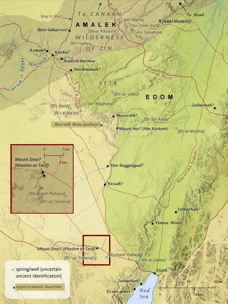
After the Israelites received the law on Mount Sinai, which may have been located at Khashm et-Tarif (see also “The Route of the Exodus”), they traveled to Kadesh-barnea, a distance that took eleven days “by the way of Mount Seir” (Deuteronomy 1:2). The phrase “by the way of Mount Seir” suggests that more than one route existed between Mount Sinai and Kadesh, as shown here, but the road the Israelites took probably ran alongside the mountainous region of Seir. This route would have offered greater access to water from wells, natural springs, and seasonal streams flowing from the hills of Seir–a critical necessity for a large group traveling through this very arid region. Nearly every location identified on this map was essentially a small community centered around one of these life-enabling sources of water. After reaching Kadesh in the wilderness of Zin, the Israelites prepared to enter Canaan by sending spies to scout out the land. But when ten of the twelve spies brought back news about the strength of the Canaanites, the people became afraid to enter the land, so the Lord punished them by condemning them to travel in the wilderness for forty years until that generation died off. Some Israelites repented and tried to enter the land, but they were beaten back to Hormah by the Amalekites and Canaanites. So for forty years the Israelites traveled from place to place, probably in the general area of Kadesh-barnea, though very few locations mentioned are able to be established with much certainty. As the forty years of traveling drew to a close, the Israelites prepared again to travel to Canaan by requesting permission from the king of Edom to pass through his land. When the king refused, the Israelites “turned away” from the Edomites and set out from Kadesh to travel to Mount Hor. The Jewish historian Josephus located Mount Hor at Jebel Nebi Harun, a very tall mountain in eastern Edom, but this has been rejected by many scholars in favor of other sites such as Jebel Madeira to the northeast of Kadesh. This author is convinced, however, that any candidate for Mount Hor must be sought to the south of Kadesh-barnea. Numbers 33:30 and Deuteronomy 10:6 mention that, during their wilderness travels, the Israelites camped at Moseroth/Moserah, which was apparently located at Mount Hor, since both Moseroth/Moserah and Mount Hor are cited as the place where Aaron died (Numbers 21:29-29; 33:37-39; Deuteronomy 10:6-9). It is difficult to envision the Israelites traveling back to the edge of Canaan after suffering defeat there the last time they attempted to enter the land. These same passages also note that after their stay at Moseroth/Moserah the Israelites traveled to Hor-haggidgad/Gudgodah (probably located along the Wadi Khadakhid) and then to Jotbathah, with no mention of passing through Kadesh, which they would have had to do if Mount Hor was north of Kadesh (since they were avoiding the land of Edom). Also, in Deuteronomy 2:1 Moses says that after the Israelites left Kadesh, “we journeyed back into the wilderness, in the direction of the Red Sea, as the Lord had told me and skirted Mount Seir for many days,” and Aaron’s death on Mount Hor fits best during this time. Similarly, Numbers 21:4 says “from Mount Hor they set out by the way to the Red Sea, to go around the land of Edom,” but there would have been no way to the Red Sea around the land of Edom if Mount Hor were located northeast of Kadesh. One element of the wilderness narratives that appears to favor a northeast location for Mount Hor, however, is the story of the king of Arad, which the book of Numbers (chapters 21 and 33) places immediately after the death of Aaron on Mount Hor. At first glance, the narrative seems to imply that the king attacked the Israelites at Mount Hor, which fits better with a northern location. Yet, it is also possible that the story is simply noting that it was after the Israelites’ arrival at Mount Hor that the king of Arad first learned of the Israelites’ renewed intentions to enter Canaan, perhaps as a result of their request to pass through Edom. But it may have been later that the king of Arad actually engaged them in battle, perhaps as they were passing north of Zalmonah and appeared to be ready to enter Canaan by way of Arad (see Numbers 33:41-42 and the map “The Journey to Abel-shittim”). For these reasons, this author believes that Har Karkom is the best candidate for the location of Mount Hor. The site is appropriately located at the edge of Seir and along the way to the Red Sea. This site’s role as an ancient cultic center is also well established. Perhaps Aaron’s priestly duties and authority in Israel had grown out of a similar role he had previously held at Mount Hor (see also Numbers 12:1-2; Deuteronomy 33:2; Judges 5:4-5), where he was eventually buried.

⤓ download hi-res file         ⧗ see in TimeGlider

The Route of the Exodus

Exodus 13-19; Numbers 33

Like several other events recorded in Scripture, the Bible’s account of the Israelites’ journey from Egypt to Mount Sinai includes an abundance of geographical references, yet it remains one of the most hotly debated topics among scholars, and numerous theories have been offered. The vast majority of geographical references provided in the story are disputed, including the place where the Israelites crossed the Red Sea, the location of Mount Sinai (see Proposed Locations for Mount Sinai map), and the various stops along the Israelites’ journey. A few locations have been established with some degree of scholarly consensus, but even these are not without opposing viewpoints. Amidst this incredible diversity of opinion, however, a single verse provides one of the most helpful clues for weighing the merits of one viewpoint over another: “By the way of Mount Seir it takes eleven days to reach Kadesh-barnea from Horeb” (Deuteronomy 1:2). For those who assume the Bible’s account to be trustworthy, this verse appears to require the following for any theory to be considered viable: 1) Kadesh-barnea and Mount Sinai must have been located at a distance from each other that could reasonably have been expected to take eleven days for an entire nation of people with small children, flocks, equipment, and perhaps even elderly members to travel on foot; and 2) the pace established by this distance over eleven days should most likely be considered the typical pace for the Israelites as they traveled from place to place along the other parts of the journey. This two-pronged test clearly strains many of the theories put forth to this point, especially when one factors in the time references given for the start of the journey (Exodus 12:6; Numbers 33:3), the middle of the journey (Exodus 16:1; Numbers 33:8), and the end of the journey (Exodus 19:1). In short, the journey from Rameses to the Wilderness of Sin took 31 days, since it included the 15th day of the second month, and the rest of the journey took another 16 days, assuming they arrived at Mount Sinai on the 15th day (not the first day, etc.) of the third month. Along with these criteria, a theory’s overall congruence with other established geographical and archeological data should bolster its credibility over other proposals. Another consideration is the extreme similarity between the events at Rephidim (Exodus 17) and the events at Kadesh-barnea (Numbers 20:1-13; 27:12-14; Deuteronomy 32:51; Ezekiel 47:19; 48:28), raising the question of whether Rephidim (meaning “resting places”) is in fact the various oases surrounding Kadesh-barnea. With these things in mind, the map below proposes a route for the exodus that meets virtually all of these criteria. A careful analysis and explanation of all the elements of the map is far beyond the scope of this article, but a few key points should be noted. The term Red Sea, in addition to referring to what we now regard it, must have also applied to the interconnected lakes and marshlands that lay along what is now the Suez Canal. Also, the portion of the journey that passed through the wilderness for three days without water (Exodus 15:22; Numbers 33:8) may have been comprised of a partial first day, a full second day, and a partial third day, much like Jesus’ time in the tomb is reckoned as three days in Matthew 12:40. Most notably, Mount Sinai is placed on this map at Gebel Khashm et-Tarif, which is appropriately located near, but not in, Midian (Exodus 3:1; 18:5; Numbers 10:29-30). It is also located 89 miles from Kadesh-barnea (assuming Kadesh is at Tall al-Quderat), which establishes a reasonable pace of 7.6 miles (12.2 km) per day to travel between them in 11 days. This lines up well with several known sources of water along that route (e.g., `Ain Qedeis [Hazar-addar?], Tamilat Suwelima [Hor-haggidgad?], and the spring at Kuntillet al-Girafi [unknown ancient identification]). This general pace then synchronizes very well with the timetable and distances required by this map for the other parts of the journey. The distance from Rameses to the Wilderness of Sin (where it is located here) could be completed in under 26 days, leaving an acceptable buffer of about 5 days for the parting of the Red Sea and perhaps a slower pace through the Wilderness of Shur/Etham. The entire journey took about 60 days, and the journey from the Wilderness of Sin to Mount Sinai took about 29 days. This leaves an acceptable buffer of time to complete the rest of the journey (about 16 days of travel) with a very adequate two weeks of extra time for Jethro to visit Moses and the Israelites to do battle with the Amalekites (Exodus 17-18). It should be noted that this timetable generally assumes (but does not necessarily require) that travel continued on sabbath days, but Scripture does not make clear whether travel was prohibited as work prior to the giving of the law at Mount Sinai.

⤓ download hi-res file

Detailed View of the Route of the Exodus with Typical Daily Spans Marked:

⤓ download file

⤓ download hi-res file

⧗ see in TimeGlider

Edom and Libnah Revolt

2 Kings 8:16-24; 2 Chronicles 21:1-11

Throughout history–from ancient times to modern–the death of a powerful leader has often initiated a cascade of political changes within the leader’s former sphere of influence, and the death of King Jehoshaphat of Judah was no different. The nation of Edom had been subjugated by King David of Israel (2 Samuel 8:13-14), and after the northern tribes of Israel broke away from the rule of David’s descendants in 930 B.C., Edom remained under the rule of Judah. By the end of the reign of King Jehoshaphat of Judah, however, the political landscape had changed significantly. Edom’s neighbor Moab had already declared independence from Israel after the death of King Ahab just a few years earlier in 853 B.C. (2 Kings 1:1; 3:5), and they had even survived an attempt by King Jehoram of Israel to bring them back under his rule (2 Kings 3; see map). Their success may have emboldened Edom to seize upon a new window of opportunity to reestablish their own sovereignty when King Jehoshaphat died in 848 B.C. Edom, too, would survive an attempt by another King Jehoram–King Jehoram (or sometimes Joram) of Judah–to bring them back under his rule, and this apparently led the Levitical city of Libnah to revolt from Judah as well. After Edom declared their independence, Jehoram set out with his chariots and his army to attack Edom at Zair (probably the same as Zoar), but the Edomites and their chariot commanders surrounded his forces, and Jehoram’s army fled home.

⤓ download hi-res file         🔍 see in TimeGlider

Israel and Judah Attack Moab

2 Kings 3

Soon after King Jehoram ascended to the throne of Israel in 852 B.C., he invited King Jehoshaphat of Judah to go with him to attack Moab. The nation of Moab had revolted against Israel’s rule after King Ahab died in 853 B.C. (2 Kings 1:1), and then Moab immediately formed an alliance and attacked Judah (1 Chronicles 20; see map). King Jehoram’s intent in attacking Moab was no doubt to bring them back under Israel’s rule. Jehoshaphat agreed to help Jehoram, and apparently King Mesha of Edom joined them as well, since Edom was still subject to Judah at this time. They chose to approach Moab from the south instead of the north, perhaps to avoid both the nation of Ammon and also the tribal territory of Reuben, which Moab had been striving to recapture for many years (see map). Though the passage mentions that the king of Edom set out on the journey with the other two kings, it is likely that Edom’s full army met up with the other armies further south. After marching for seven days, the armies were running out of water, so they consulted the prophet Elisha, who must have been in the area at the time. Elisha foretold that a nearby stream would be soon be filled with pools of water even though it would not rain there, and the armies of Israel would conquer every fortified city of Moab and ruin the land. The next day water flowed into the area from the direction of Edom. This must have occurred near the border of Moab, because the Moabites saw the pools of water as well. The Moabites mistook the water in the morning sunlight for blood from the armies fighting each other, and they attacked them, expecting to seize the plunder. Instead, the armies of the Israelite alliance rose up and attacked them, and the Moabites fled. The forces of the Israelite alliance pressed on to Moab itself and conquered all the fortified cities and ruined the land, as Elisha had foretold. Only the fortified city of Kir-hareseth withstood their attack. King Mesha of Moab attempted to break through the Edomite line of the Israelite alliance, but his plan failed. So he sacrificed his firstborn son and offered him as a burnt offering on top of the wall, causing great wrath to come upon Israel, and the armies of the Israelite alliance withdrew to their own land.

⤓ download hi-res file         🔍 see in TimeGlider

Israel Battles Benjamin

Judges 20

[Author’s note: The ideas presented in this article about Israel’s battle with Benjamin are openly recognized as uncertain, but the author’s intent is that they would lead to further study and discussion by others, which may in turn lead to greater clarity and refinement of understanding regarding the geographical details of this story.]

The battle between the tribe of Benjamin and the other Israelite tribes during the time of the Judges was precipitated by horrific acts committed by the men of Gibeah as well as by a Levite passing through the town. The story is a candid account of the brutality and chaos that ruled much of Israel before the time of the kings (Judges 21:25). In the story, the Levite calls for the other tribes to address the deeds committed by the men of Gibeah. After gathering at Mizpah, the tribes demand that the Benjaminites hand over the men, but the Benjaminites refuse, leading to a war with the other tribes. Before the battle begins, the Israelites consult the Lord at Bethel, where the Ark of the Covenant is located (Judges 20:27). Then they travel down the Central Ridge Route, which ran north-south along the watershed of Israel, and attack Benjamin, but they suffer a huge defeat and return to Bethel. The same thing happens the second day. In preparation for a third attack, the Israelites set up an ambush near Gibeah, likely west of Gibeah (rather than Geba, as sometimes translated; Gibeah, Geba, and Gibeon–all forms of the word “hill”–were sometimes confused by copyists of Scripture). The main army then attacks from the north as before, and the Benjaminites meet them in battle, but the main army falls back to Baal-tamar, possibly the same as the palm (tamar) of Deborah mentioned in Judges 4:5, and this draws the Benjaminites further away from the city. Then those waiting in ambush rush upon Gibeah and destroy it. Smoke rising from the city signals the main Israelite army to turn again and press the attack against the Benjaminites. The Benjaminites, knowing disaster is upon them, turn “away from the Israelites in the direction of the wilderness” and take refuge at the rock of Rimmon. The nearly universal assumption by scholars is that the Benjaminites fled east, no doubt because of two assumptions about the text: 1) that the term wilderness in Israel only referred to areas east of the watershed, and 2) that verse 43 makes it clear that the Benjaminites were chased “east of Gibeah” (or perhaps Geba). It may well be that the Benjaminites fled east, but this author believes there is adequate evidence to support the possibility that they fled west instead. As noted in the article regarding the battle at the pool of Gibeon (see here), the term wilderness (midbar) in Scripture is almost always used to refer to locations east of the watershed of Israel, but the patriarch Reuben also used the term to refer to the sparsely populated area near Dothan west of the watershed (Genesis 37:22; see map here). Likewise, the term wilderness in this passage may refer to the sparsely populated region west of Gibeon. Additionally, the phrase typically translated “east of Gibeah” in verse 43 may have actually meant “east of Gibeon” (see a similar example in 2 Samuel 21:6). Also, in verse 45 the term Gidom, meaning “a cutting down,” is typically translated as a place name, but instead it may mean that they continued to cut them down as far as they chased them (see NEB and The Message). Finally, this author has found a viable candidate for the rock of Rimmon at Khirbat Rummana (31.8415 N, 35.1039 E), located on a hill in the heart of the sparsely populated area labeled here as the wilderness of Gibeon.

⤓ download hi-res file         🔍 see in TimeGlider