Though the patriarch Isaac moved from place to place several times within southern Canaan, compared to his father Abraham and his son Jacob, Isaac appears to have been a bit of a homebody. In fact, unless Isaac resettled in places not recorded in Scripture, the farthest extent he ever traveled appears to have been only about 90 miles (145 km). Yet, as the child of God’s promise to Abraham to build a great nation from his descendants, Isaac’s relatively simple life served as a critical bridge from Abraham to the beginnings of the twelve tribes of Israel, who were descended from Isaac’s son Jacob. It is likely that Isaac was born at Beersheba (see Genesis 21:1-24), and later Abraham offered him as a sacrifice on Mount Moriah (located at Jerusalem; see 2 Chronicles 3:1). Then Abraham, Isaac, and those with them returned to Beersheba (Genesis 22:1-19). When Isaac reached adulthood, his father sent a servant to bring back a bride for him from Aram-naharaim, far north of Canaan. When his bride, Rebekah, arrived, Isaac had just come from Beer-lahai-roi and settled in the Negev (Genesis 24:62). Later Isaac resettled with Rebekah in Beer-lahai-roi, and this may have been where their twin sons Esau and Jacob were born. A famine forced Isaac to go to Gerar (Genesis 26:1-6) in “the land of the Philistines.” The distinct people group known as the Philistines in later books of the Bible did not arrive until the time of the Judges, so the term here must have referred to another people group living in this region, and this is supported by the fact that King Abimelech’s name is Semitic, not Aegean (the likely origin of the later Philistines). While Isaac was there, he repeated his father’s error (Genesis 20) by lying to the king that his wife was only his sister. Isaac also became increasingly prosperous at Gerar, so the Philistines told him to leave their region. Isaac moved away from the town of Gerar and settled further away in the valley of Gerar. There he dug a well, but the Philistines claimed it for themselves, so he called it Esek, meaning “argument.” So Isaac’s men dug another well and called it Sitnah (meaning “hostility”), but it led to more quarreling, so he dug yet another well and called it Rehoboth (meaning “open space”). The locations of these two later wells are not certain, but they may have been located near Ruheibeh as shown on this map. Then Isaac moved to Beersheba and built an altar. He also dug a well there, and King Abimelech of the Philistines came and exchanged oaths of peace with him. It was likely at Beersheba that Isaac blessed his sons Esau and Jacob, and both sons eventually left Canaan (see “Jacob Goes to Paddan-Aram” map). When Jacob later returned, he traveled to Mamre near Hebron and reunited with Isaac (see “Jacob Travels to Southern Canaan” map). Sometime after this Isaac died, and Jacob and Esau buried him there.
The book of Genesis twice records the origin of the Ishmaelites, who were descended from Ishmael, the son of Abraham by Sarah’s handmaiden Hagar. Ishmael lived in the wilderness of Paran (Genesis 21:20-21), and his descendants eventually ranged from Shur near Egypt all the way around to Havilah on the Arabian peninsula (Genesis 25:12-18), as shown on this map that depicts the region around the time of the Judges. Yet the term Ishmaelite also appears to have referred in a more general sense to any of the nomadic groups that roamed the deserts of Sinai and Arabia, because the Midianites (another group descended from Abraham by his second wife Keturah; Genesis 25:1-2) are twice referred to as Ishmaelites: once when Joseph is sold to a group of Midianite traders traveling from Gilead to Egypt (Genesis 37:28-36), and again when Gideon is collecting gold earrings from the spoil taken from the Midianites (Judges 8:24). Likewise, the term Hagrites, (likely meaning those descended from Hagar), is applied at times to a tribal group that appears to have been among those descended from Ishmael, but in 1 Chronicles 27:30 the terms Ishmaelite and Hagrite are applied to two different people, indicating that the terms were not synonymous. Twelve tribes are specifically listed by Genesis as descending from Ishmael, similar to how Israel was reckoned as being comprised of twelve tribes descended from a single patriarch (Genesis 35:23-26). While some of the Ishmaelite tribes achieved political dominance during certain periods of biblical history, the twelve tribes never operated as a single, unified nation. The physical boundaries of each Ishmaelite tribe’s nomadic range is difficult to establish with much certainty, partially because nomads, by definition, continually move to new lands as needed to feed their flocks. Even so, a few clues from Scripture and other ancient sources point to the likely general range for each tribe, as shown on this map.
Nebaioth has often been speculated to be the same tribe that was later called the Nabateans, but the variance in the Hebrew spelling between the two names makes this identification unlikely. Rather, they were probably the Nabaiate of Assyrian documents, which mention them in close association with the tribe of Kedar. Nebaioth and Kedar are also mentioned together in Isaiah 60:7.
Kedar, the most prominent and powerful of the Ishmaelite tribes, lay to the southeast of Israel, and this is confirmed by Jeremiah’s comment in Jeremiah 2:10 that speaks of Cyprus and Kedar as lying on opposite sides of Israel. Kedar attained significant political strength during the ninth century B.C. until they were absorbed into the Nabatean empire in the first century B.C.
Adbeel was likely a tribe known by the Akkadians as the Idibilu, who were eventually conquered by Tiglath-pileser III of Assyria and employed to guard the approaches to Egypt’s borders.
Mibsam may be named after the word for “sweet odor,” suggesting that they may have been one of the people groups of western Arabia who produced world-renowned incense and transported it to ports along the eastern Mediterranean Sea.
Mishma may have been centered around a mountain called Jebel Mishma today.
Dumah was likely centered around the ancient Arabian city by the same name.
Massa was known to the Assyrians as Mas’a, and they were forced to pay tribute to Tiglath-pileser III. Ptolemy knew the tribe as the Masanoi and located them to the northeast of Dumah.
Hadad is somewhat unknown in ancient sources, although today there is an Arabian tribe named Hadad that are mostly Christians, and they are located throughout the Levant.
Tema was no doubt centered around the city by the same name, and it was located near the rival oasis of Dedan. King Nabonidus of Babylon made Tema his headquarters as he gained control over the other Arabian desert oases (see Jeremiah 49:28; also see “Oases of the Arabian Desert” map).
Jetur was likely located northeast of Gilead, because 1 Chronicles 5:18-22 records how the Reubenites, the Gadites, and the half-tribe of Manasseh attacked Jetur and the tribe of Naphish, captured many of them and their livestock, and occupied their territory until the time of the exile. By the time of Jesus, this tribe was known as the Itureans and had captured land just north of Israel.
Naphish was likely located just east of Gilead, because the Reubenites, the Gadites, and the half-tribe of Manasseh attacked them and the tribe of Jetur and occupied their territory until the time of the exile (1 Chronicles 5:18-22).
Kedemah may have been located near the Reubenite town of Kedemoth.
Though Scripture sometimes refers to various tribes of Ishmael as enemies of Israel (1 Chronicles 5:18-22; Psalm 83:5-8), Isaiah also prophesied to Israel of a glorious day coming when “all the flocks of Kedar shall be gathered to you, the rams of Nebaioth shall minister to you; they shall be acceptable on my altar, and I will glorify my glorious house” (Isaiah 60:7).
The harrowing experience of the attack on Judah by King Sennacherib of Assyria during Hezekiah’s reign is recorded by three different writers of Scripture and even by Sennacherib himself. Many scholars also suspect that this event formed the basis for Herodotus’s story regarding an army of mice eating the bow strings of the Assyrian army during their campaign against the Egyptians (Histories, 2.141). The origins of this event stretch back into the reign of Hezekiah’s father Ahaz, who enticed the Assyrians to attack Israel and Aram in exchange for making Judah a vassal of Assyria (2 Kings 16-17; 2 Chronicles 28; Isaiah 7-8; also see “The Final Days of the Northern Kingdom of Israel” map). Judah continued to be a vassal of Assyria through the early part of Hezekiah’s reign, but Hezekiah also quietly made extensive preparations to throw off the yoke of Assyria one day (2 Kings 18:1-12; 1 Chronicles 4:39-43; 2 Chronicles 29-31; also see “Hezekiah Strengthens Judah” map). Hezekiah also appears to have been hoping for support from Babylon and Egypt regarding his efforts to revolt against Assyria’s rule, but the prophet Isaiah warned Judah against placing their hopes in these foreign powers (Isaiah 30:1-5; 31:1-3; 39:1-8; 40:10-15; 2 Kings 20:12-19). After a few years spent quashing rebellion among the Babylonians, the Kassites, and the Medes in the east, Sennacherib turned his sights westward and began a campaign to subdue the various vassal nations that were refusing to submit to Assyria’s rule any longer. He first reconquered the Phoenician cities of Sidon and Tyre and then moved south to Philistia. He subdued Joppa, Beth-dagon, Bene-berak, and Azor and then moved to capture the cities of the Shephelah, which guarded the entrances to the valleys leading into the central hill country of Judah. While Sennacherib was attacking Lachish he sent his officers to demand Hezekiah’s surrender. This may be the Assyrian advance upon Jerusalem from the north described in Isaiah 10:28-32, but this is not certain (see “Assyria Advances on Jerusalem” map). Hezekiah sent officers back to Sennacherib with gold and silver taken from Temple and the royal treasury, but he would not surrender. The officers then traveled to Libnah to meet with Sennacherib, for he gone to fight there by that time. In the meantime King Tirhakah of Cush, who was ruling over Egypt at this time, came to attack Sennacherib, so Sennacherib sent his officials back to Hezekiah with a message that Jerusalem would be taken if he resisted. Hezekiah laid the letter from the officials before the Lord and prayed, and the Lord sent word through the prophet Isaiah that Jerusalem would not be taken. Then that very night the angel of the Lord killed 185,000 Assyrian soldiers (probably those with Sennacherib fighting the Egyptians), and Sennacherib went back to Assyria. There while he was worshiping in the temple of Nisroch, Sennacherib’s sons killed him and fled to Ararat (see “Ararat” map).
As with many of the stories of the Bible, the events of Jacob’s life are often misunderstood by readers as disjointed pericopes arranged primarily for theological and cultural purposes. Because of this, readers often fail to see that these stories follow a clear geographical progression of the patriarch throughout the land of Canaan. This realistic and coherent geographical framework behind the stories gives strong support to the belief that these stories are authentic, historical accounts of the experiences of Jacob and his ancestors. The overall framework for virtually all of Jacob’s stories is very simple: Jacob is born and raised in southern Canaan but comes into conflict with his twin brother Esau, so he flees to Paddan-aram in Mesopotamia (Genesis 25-28; see “Jacob Goes to Paddan-Aram” map). There he builds a large family and great wealth (Genesis 29-30) and eventually returns to southern Canaan, likely retracing the exact steps he followed when he fled (Genesis 31-35; see also “Jacob Returns to Canaan” map). During this time, Esau moves to the hill country of Seir, likely just south of southern Canaan (“Edom and the Land of Seir” map), and establishes his own family there, giving rise to the nation of Edom (Genesis 36). Though the primary intent of Jacob’s return was no doubt to resettle in Canaan, comments made during his reunion with Esau near Peniel may reveal that he also intended to travel even further to Seir to visit his brother there (Genesis 33:12-14). After crossing from Mahanaim to Peniel in Gilead, Jacob reunites with Esau and settles in Succoth for a time and builds a house for himself and booths for his cattle. He eventually crosses the Jordan River and enters Canaan, stopping first at the ancient city of Shechem. There Jacob’s daughter Dinah is defiled by the son of the region’s leader, and her brothers take revenge by killing all the men of the city. Thus, Jacob is forced to leave, but first he calls upon all his household to purify themselves. He collects their idols and rings and buries them beneath a tree in Shechem. Upon reaching Bethel, Jacob builds an altar and calls it El-bethel. The nurse of Jacob’s mother Rebekah also dies at Bethel and is buried under an oak below the town, leading them to call the place Allon-bacuth (“oak of weeping”). Jacob and his family leave for Bethlehem, but very soon after they start the journey Rachel gives birth to Benjamin and then dies. Jacob buries her along the way, apparently near a place called Zelzah (or perhaps Elzah; see 1 Samuel 10 and “Saul Searches for His Donkeys” map; see also Jeremiah 31:15, which supports that Rachel was buried near Ramah). Jacob continues on and camps beyond the tower of Eder, perhaps near Bethlehem, since that seems to have been his original destination. Finally Jacob reaches Mamre and Hebron. Soon after this Isaac dies, and Esau and Jacob bury him. The story of Jacob’s journey ends at Genesis 35, and we are not explicitly told if Jacob traveled even further to Seir. Genesis 36, however, catalogs the descendants of Esau, the Edomites, perhaps indicating that Jacob did indeed fulfill the intentions he stated in Genesis 33:12-14.
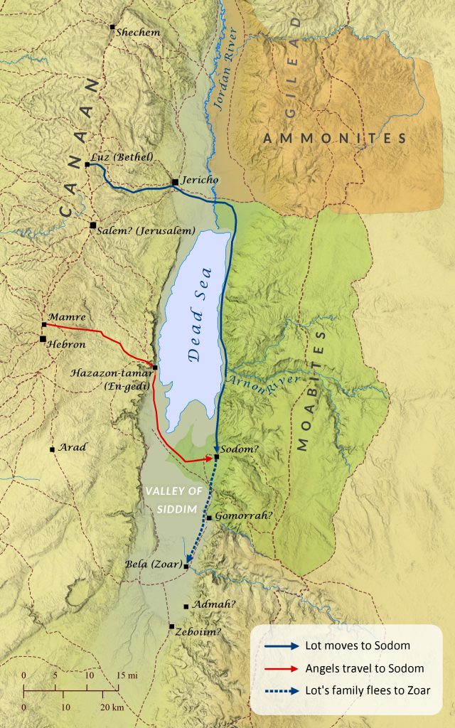
Author’s note: This article assumes that Sodom, Gomorrah, and Bela (Zoar) were located at Bab edh-Dhra, Numeira, and Khirbat ash-Sheikh `Isa, respectively. The exact locations of the cities of the plain are widely debated, with the primary dispute centering around whether the cities are to be found in the northern area of the Dead Sea (since Lot headed east from Bethel [Genesis 13]) or the southern area (as the Medeba Map shows). It is beyond the scope of this article to present all the evidence to support a southern location, but many of them are well summarized here: “The Discovery of the Sin Cities of Sodom and Gomorrah.” In addition, Eusebius in his Onomasticon describes the Dead Sea as lying between Jericho and Zoar. This author has also recently found that Eusebius notes that Nebereim (Nimrim; see Isaiah 15:6 and Jeremiah 48:34) is located at a village called Bennamareim (likely the site of Gomorrah on this map), which he also says is north of Zoar. Thus, if Eusebius is correct, Zoar is clearly located in the southern area of the Dead Sea, which fits very well with the location shown on this map. Also, Lot’s relocation to Sodom after moving east to the plain of the Jordan suggests that Sodom was located on the east side of the Dead Sea.
The famous cities of Sodom and Gomorrah are first mentioned in Genesis 10:19 in a description of the territory of the Canaanites. The cities are mentioned again in chapter 13, which notes that while Abraham (then called Abram) was living near Bethel (also called Luz), tension began to grow between Abraham’s herders and the herders working for Abraham’s nephew Lot. To resolve the problem, Abraham suggested that he and Lot permanently part ways, and he offered Lot first choice of where to live. Lot chose to move east to the plain of the Jordan, because the land was well watered, and he eventually settled in the city of Sodom. Genesis 14 then describes how Lot was captured by four Mesopotamian kings as they attacked the cities of the plain, but Abraham rescued Lot (see “The Battle at the Valley of Siddim” map). Sometime after this Abraham moved to the oaks of Mamre, near Hebron, and three visitors (one of whom is later called “the Lord,” and the other two “angels”) approached his tent. Abraham invited them to share a meal with him and then later accompanied them for the first part of their journey. Along the way the visitors revealed to Abraham that they were going to Sodom to destroy it for its wickedness. Abraham appealed to the Lord to spare the city if even a few righteous lived there, and the Lord agreed and went his way. The two angels arrived at Sodom in the evening (Genesis 19:1), presumably the same day they left, although perhaps they actually took more than one day to travel to Sodom, because the distance from Mamre to Sodom is over 35 miles (56 km), and Scripture does not specifically note that it was the same day. The events that followed that evening are well known, and in the morning the angels compelled Lot and his family to flee the city before it was destroyed. The angels instructed them to flee to the hills, but Lot convinced them to allow him to take refuge in a small village on the plain and not destroy it. Genesis 19:23 seems to suggest that it took Lot’s family a full day and night to reach Zoar, which fits well with the 16 mile (25 km) distance from Sodom to Zoar. As they were reaching Zoar, the Lord rained down fire and burning sulfur on Sodom, Gomorrah, Admah, and Zeboiim, completely destroying them. As Lot’s family was still fleeing, Lot’s wife looked back and turned into a pillar of salt. That same morning Abraham got up and went to where he had last spoken with the visitors, and when he looked out across the plain he saw columns of smoke rising from the destroyed cities. Later Lot and his daughters moved into the hills and lived in a cave, because they were afraid to remain in Zoar. Fearing they would never marry, Lot’s daughters both got their father drunk and conceived children by him, though he was unaware of it. These children became ancestors of the Moabites and the Ammonites.


