Numbers 20:14-21:20; 33:37-49; Deuteronomy 2:1-23; Judges 11:14-27
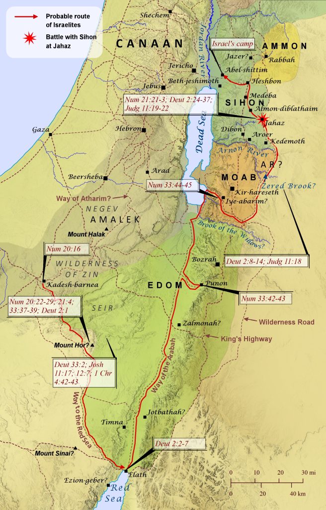
Four separate passages of Scripture recount the Israelites’ journey from Kadesh-barnea to Abel-shittim, yet precisely tracing this route on a map is surprisingly difficult. Most of the specific locations mentioned are either unidentified or uncertain, and some comments about the journey can seem difficult to reconcile with other comments. Yet the relevant passages provide enough geographical markers that can be identified with reasonable confidence to make it possible to reconstruct what was likely the route they took to Abel-shittim (shown here). From its earliest days, Edom controlled the area known as Seir, southeast of Kadesh-barnea (see Deuteronomy 33:2; Joshua 11:17; 12:7; 1 Chronicles 4:42-43), which is why the Israelites told the king of Edom that they were on the edge of his territory while they were still at Kadesh-barnea (Numbers 20:16). When the king of Edom refused their request to pass through his land, Israel turned back (Numbers 20:21; Deuteronomy 2:1) and apparently headed southeast, skirting the Edomite land of Seir. Two passages mention Mount Hor, where Aaron died, as one of the first stages on the Israelites’ journey (Numbers 21:4; 33:37), but it is unclear where this mountain was located. A popular tradition locates it about 22 miles (35 km) south of Punon at Jebel Harun, but this location is too far from Kadesh-barnea to be one of the first stops on their journey, and at this time it was in the middle of Edom’s territory rather than on the edge of it, as both passages imply. Any candidate for Mount Hor must have been southeast of Kadesh-barnea, since Israel “turned back” to begin their journey, and Har Karkom (as shown here) fits these requirements. Then, in an apparent shift from earlier, Israel passed through Edom (Numbers 33:42-43; Deuteronomy 2:2-6) and turned from the Way of the Arabah to camp at Iye-abarim. The town of Iye-abarim was most likely located at Khirbat `Aiy, as shown on this map, for several reasons. To begin with, the predicate “-abarim” before “Iye” likely indicates that it was situated among the Abarim Mountains, which ran along the eastern shore of the Dead Sea. Also, Numbers 33:44 notes that Iye-abarim was located “in the territory of Moab,” though the Israelites were ultimately making their way to the Wilderness Road outside the bounds of Moab (Deuteronomy 2:8; Judges 11:18). Finally, the Medeba Map clearly identifies a town named Ai (a variant spelling of Iye) at the exact location of Khirbat `Aiy.[see footnote] Then, after passing Moab on the east along the Wilderness Road, the Israelites camped in the Zered Valley (likely the Wadi e-Tarfawiya as shown here and not the Wadi al-Hasa, which was likely the Brook of the Willows mentioned in Isaiah 15:7), and then they camped again on the other side of Arnon River (Numbers 21:11-12; 33:44-45). Then the Israelites sent messengers to Sihon, asking permission to pass through his land (Numbers 21:21-22; Deuteronomy 2:24-29; Judges 11:19). Years earlier Sihon had taken the land north of the Arnon River from the Moabites (Numbers 21:26), which explains why this area was still referred to as Moab at times (e.g., the plains of Moab). The region also appears to have been claimed by the Ammonites as well (Judges 11:13), though it is not clear whether they ever actually controlled it. Sihon also took half the land of Ammon as well (Joshua 13:25; see “Sodom and Gomorrah Are Destroyed” map). Sihon refused to allow the Israelites permission and instead attacked them at Jahaz, but the Israelites defeated him and took his land for themselves (Numbers 21:23-31; Deuteronomy 2:30-36; Judges 11:20-22). Then they set up camp at Abel-shittim and prepared to enter the Promised Land of Canaan (Numbers 33:48-49).
[footnote: Though virtually all translations understand Numbers 21:11 as placing Iye-abarim in the wilderness that is east of Moab, this author is convinced that it is saying instead that Iye-abarim is in the wilderness that faces (Hebrew panim) Moab when looking eastward. Other examples of the use of the word faces to place something in a non-eastern position relative to another object by indicating the point of view of the reader include Joshua 13:24-25 (Gad’s boundary could not have included a town that was east of Rabbah) and Joshua 18:14 (it seems to make the most sense that the hill in view is probably the prominent hill to the north of Beth-horon–that is, before it when looking southward).]