The long and prestigious history of Ephesus, a valuable port city in western Anatolia, stretches back at least as far as 1440 B.C., when the city was likely the capital of the kingdom of Arzawa. Later, Greek peoples inhabited Ephesus and built a temple to the goddess Artemis on the site. After this first temple was destroyed in a fire, the Ephesians rebuilt it, and it was later recognized by the historian Herodotus as one of the seven wonders of the ancient world. Over time, the continual silting of the Cayster River forced the population to move westward, so that by the time Paul visited Ephesus it had relocated to where it is shown here, and its small harbor had to be constantly dredged to keep it navigable. By this time Ephesus had become one of the largest and most prestigious cities of the Roman Empire, but the progressive decline of its value as a port forced it to depend increasingly on income generated from pilgrims to the temple of Artemis. It is no surprise, then, that Paul’s prolonged ministry in Ephesus during his third missionary journey drew the ire of silversmiths and sellers of small shrines of Artemis, who feared his ministry would jeopardize their business (Acts 19:23-41). They stirred up a large crowd, seized two of Paul’s companions, and rushed into the theater, where they shouted, “Great is Artemis of the Ephesians!” for two hours. After the crowd eventually settled down and dispersed, Paul left for Macedonia (Acts 20:1). Years later the apostle John relocated his ministry to Ephesus along with Mary the mother of Jesus, whom Jesus had committed to his care (John 19:25-27), and it was likely from here that John wrote his three epistles. Ephesus is also one of the seven churches John addressed in the book of Revelation (2:1-7). Not long after this the Romans abandoned the burdensome task of dredging the small harbor, which then became unusable, thus forcing the city to slowly migrate westward once again. The modern shoreline now lies over 3 miles (5 km) west of Roman Ephesus.

Israel Enters the Promised Land
Joshua 2-8
After Moses died, Joshua became the leader of the Israelites, and he led them to the Jordan River to prepare to enter the Promised Land. Priests carried the ark of the covenant before the Israelites, and as soon as their feet touched the water, which was in the midst of seasonal flooding, the waters were blocked upstream at Adam, and the Israelites crossed into the Promised Land on dry ground. The Israelites collected twelve stones from the middle of the river and set them up at their camp in Gilgal as a memorial of the event. While they were at Gilgal, all the Israelite males were circumcised, and the people celebrated the Passover. From that time on, manna no longer appeared from heaven for them. Nearby, the ancient, well fortified city of Jericho stood guard over the entrance to the rest of Canaan. After marching around the city each day for seven days, the Israelites watched its walls fall flat, and then they were able to capture the city. The family of Rahab the prostitute was spared from death because she had hidden two Israelite spies who were scouting out the city before the attack. Soon after this, the Israelites suffered defeat while trying to capture the small town of Ai, and the Lord revealed that it was because a man named Achan had taken some of the devoted items from Jericho. So Joshua took Achan and his family to the Valley of Achor and executed them there. Later the Israelites were able to capture Ai (see “The Israelites Conquer Ai” map). Joshua then renewed the covenant at Mount Ebal and Mount Gerizim. He built an altar there, and half the Israelite tribes stood in front of Mount Gerizim and shouted the blessings of obedience to the covenant while the other half stood in front of Mount Ebal and shouted the curses for disobedience (see also Deuteronomy 11:26-32).

⤓ download hi-res file 🔍 see in TimeGlider
Paul Is Transferred to Caesarea
Acts 21-26
After arriving in Jerusalem at the end of his third missionary journey, Paul went up to the Temple, but some Jews there started a riot, because they thought he had brought a Gentile into the Temple area and was teaching people to disregard the law of Moses. The Roman commander stationed there arrested Paul to rescue him from the crowd, and he arranged for the Sanhedrin to come and clarify why the crowd was angry with Paul. As Paul responded to the Sanhedrin’s accusations, some Jews made plans to ambush him if he was brought before the leaders again. But Paul’s nephew found out about the plot and informed the commander, who transferred Paul to Caesarea during the night under heavy guard–two hundred soldiers, seventy cavalry, and two hundred spearmen. This large detachment escorted Paul to Antipatris, and then the soldiers returned, leaving the cavalry to escort Paul the rest of the way to Caesarea. The Roman governor, Felix, resided in Caesarea, which was the main headquarters of the Roman forces in Palestine. Felix ordered Paul to be held in Herod’s palace until his accusers arrived for his trial. Five days later the high priest Ananias and several others came and made their case against Paul. Felix adjourned the proceedings without issuing judgment, and over the two years that Paul remained in prison Felix often listened to him and waited for a bribe. It is possible that during this time Paul also wrote the Prison Epistles (Ephesians, Philippians, Colossians, and Philemon). Eventually Felix was replaced by Festus, and once again the Jewish leaders requested to have Paul transferred back to Jerusalem, because they were plotting to ambush him along the way. But Festus required them to come to Caesarea to make their case against Paul. After the leaders finished making their case, however, Festus asked Paul if he would be willing to stand trial in Jerusalem, but Paul invoked his right as a Roman citizen to appeal his case to Caesar. As Paul awaited transfer to Rome, Herod Agrippa II and his sister Berenice came to Caesarea to pay their respects to Festus, and Festus requested their help to better understand the charges against Paul, since they were familiar with Jewish law. So Paul was brought before them and made his case once again.

⤓ download hi-res file 🔍 see in TimeGlider
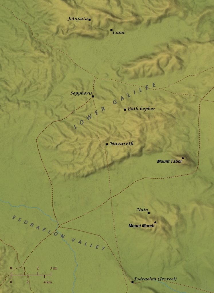
Nazareth and Its Surroundings
The apostle Paul noted that God often chooses the lowly to accomplish his will and humble the great (1 Corinthians 1:26-31). This was never more evident than when God selected Nazareth as the town where Jesus would grow up. At this time, the tiny village of Nazareth was so insignificant that, besides the New Testament, it was not referenced in any ancient writings until about 200 years after Jesus’ birth. Even the disciple Nathanael, upon hearing of Jesus’ hometown, retorted, “Can anything good come from there?” (John 1:46). Yet it was in this small town that God placed his Son, the Messiah, to grow and mature before launching his public ministry. Nazareth was perched atop one of the low lying hills of Lower Galilee overlooking the great Esdraelon (Jezreel) Valley, the scene of so many momentous battles throughout Israel’s history (Judges 4-7; 1 Samuel 28-31; 2 Kings 23:29-30; 2 Chronicles 35:20-27). Nazareth lay about three miles (5 km) southwest of Gath-hepher, the hometown of the prophet Jonah (2 Kings 14:25), and about the same distance southeast of Sepphoris, a sizeable administrative center during Jesus’ time. When the angel Gabriel announced to Mary that she would give birth to the Messiah (Luke 1:26-38; 2:4), Mary and Joseph were living in Nazareth, and then they traveled south to Bethlehem of Judea, their ancestral town, for a census. There Mary gave birth to Jesus (Luke 2:1-7). After fleeing to Egypt for a time to escape Herod’s soldiers, Joseph, Mary, and Jesus eventually returned to Nazareth, where they could find safety in the town’s relative obscurity (Matthew 2). After Jesus grew up, he performed his first miracle at a wedding in the village of Cana (John 2:1-12) about 8 miles (13 km) north of Nazareth, and he raised a widow’s son from the dead in the village of Nain (Luke 7:11-17) about 6 miles (9 km) across the valley from Nazareth.
? download hi-res file 🔍 see in TimeGlider
Jesus Is Born in Bethlehem
Luke 1-2
Joseph and Mary were living in Nazareth when the angel Gabriel announced to Mary that she would soon give birth to the Messiah. Then a census was decreed by Caesar Augustus, which required Joseph and Mary to travel about 70 miles (110 km) to Bethlehem, the town of their ancestor David, to be registered. There Mary gave birth to Jesus and laid him in a manger. Nearby shepherds were living in the fields with their sheep, and an angel of the Lord appeared to them and announced that the Messiah had been born in Bethlehem. They went and found Mary, Joseph, and baby Jesus just as the angel had said, and they went and spread the news about what they saw. Then the shepherds returned to their fields, glorifying and praising God. Eight days after Jesus was born, Joseph and Mary took Jesus to the Temple in Jerusalem to be circumcised, in keeping with Genesis 17:1-14. A few weeks later Joseph and Mary went back to the Temple a second time with Jesus so that Mary could undergo the purification rites for childbirth and Jesus could be consecrated to the Lord with a sacrifice for the firstborn son (Exodus 13:1-13; Leviticus 12). While they were there a righteous and devout man named Simeon was moved by the Spirit to come into the Temple courts, and he took Jesus into his arms during the consecration ceremony and praised God for sending the Messiah to save his people. Immediately after this a prophet named Anna, who had lived in the Temple ever since her husband had died decades earlier, came up to Joseph and Mary and gave thanks to God, and she spoke about Jesus to all who were looking forward to the redemption of Jerusalem. Sometime later, after Joseph and Mary had done all that was required in the law, they returned with Jesus to their hometown of Nazareth in Galilee.